Dates & prices
No upcoming dates yet.
This operator hasn't scheduled new dates for this trip.
About Skandagiri Hike
Everything from the adventure page, so you do not have to leave this trip.
A short, steep granite hill north of Bengaluru with an 18th-century fort and a living Shiva temple on top — Skandagiri, or Kalavara Durga, sold everywhere as the Skandagiri Trek. The Karnataka government puts the trail at 8 km there and back from the Papagni Mutt at Kalavara, while the published section table comes to 5.6 km. It is walked before dawn for the cloud sea, and only on a Forest Department ticket booked in advance — which, as of 7 September 2026, the department is not selling for this trail.
Trip details
Skandagiri is the granite hill directly behind Nandi Hills, 3 km out of Chikkaballapur town and roughly 60 to 70 km north of Bengaluru (Bangalore). It is also written Kalavara Durga, Kalavarabetta and Kalwarbetta, and the British Library holds an aquatint of it from 1794 under the name Kummaulghur. The walk starts behind the Papagni Mutt at Kalavara village — a settlement of 1,093 people at the 2011 census — and climbs in three sections to a summit carrying ruined fort walls, abandoned pillars, rock slabs with writing on them and a small Shiva temple whose idols are intact and still worshipped. How long it is depends on who you ask: Karnataka Tourism and the Forest Department's Karnataka Eco-Tourism listing both put the trail at 8 km, while the section table published by Indiahikes and by Wikipedia — 800 m from the mutt to the forest check post, 1,100 m to the rest point, 900 m to the summit — comes to 2.8 km each way, or 5.6 km there and back. We lead with the government's 8 km and print the sections so you can see where the gap is. It is two to three hours up, and published times for the whole outing run from about five hours, which Indiahikes and Wikipedia both give, to the six to eight hours Karnataka Tourism gives for the full circuit. The altitude is genuinely unsettled. Karnataka Tourism and the Forest Department's own Karnataka Eco-Tourism listing both give about 1,350 m; Wikipedia gives about 1,450 m. There is no survey figure we could find to settle a 100 m disagreement, so we publish the spread and lead with the state government's 1,350 m. Indiahikes gives no summit height at all and states the climb instead, as approximately 1,200 feet — about 365 m — of gain from the Papagni Mutt. Chikkaballapur town sits at about 915 m on an uncited Wikipedia infobox figure, which would make the ascent 435 m or 535 m depending on which summit height you take, so treat the climb as somewhere between about 350 m and 550 m. What matters more than the height is that you cannot simply turn up. The Forest Department closed these routes around 2010 after accidents; the Karnataka Eco-Tourism Development Board announced in November 2015 that it would legalise Skandagiri, Makalidurga and Savandurga from 1 January 2016, and yet in January 2016 Deccan Herald found trekkers being turned back at the foot of the hill with trekking still banned day and night, and about 80 people who went up at night were taken to a police station in a trek Deccan Herald reported in May 2016. Access today runs through the department's booking portal, aranyavihaara.karnataka.gov.in, launched on 3 October 2024 with Skandagiri among the first five trails on it, and through a standard operating procedure announced on 17 April 2026 and issued as a circular by the Principal Chief Conservator of Forests on 18 April 2026 that puts a nature guide with every ten trekkers and caps a trail at 150 people. Read the permits and hazards notes below before you plan a departure — the portal turns individual routes off, it did so state-wide for the fire season in April 2026, and since the state-wide suspension of 11 May 2026 and the reopening SOP of 30 August 2026 this route has not come back: on 7 September 2026 it was not on sale.
- Papagni Mutt at Kalavara village, the trailhead — an old mutt with a temple close by, a parking area, and a groundwater-fed water tank that Indiahikes says is the only water source on the whole trek. Fill up here.
- The Forest Department check post 800 m past the mutt, a small hut where the guard takes your government-issued ID card and enters your details in the register before you go any further, with Ecotrails information boards outside it.
- The rest point 1.9 km in — a flat, open rocky patch, which Indiahikes describes as the place to stop for five to ten minutes and take in the lush green view in front of you.
- The fort ruins in the last 900 m: fort walls, abandoned pillars and rock slabs with writing on them, appearing after about twenty minutes of that final ascent. Karnataka Tourism attributes the fort to Tipu Sultan and dates its abandonment to 1791.
- The Shiva temple at the summit, described by Karnataka Tourism as an ancient Shiva temple and by Indiahikes as still worshipped by devotees who climb all the way up, with the idols inside intact — a living shrine in the middle of an abandoned fort.
- Nandi Hills — Nandidurga, 1,478 m — seen close up from the top. Skandagiri sits directly behind it, which is a view most people who drive up Nandi Hills never get. Indiahikes puts the two about 23 km apart on the road between them.
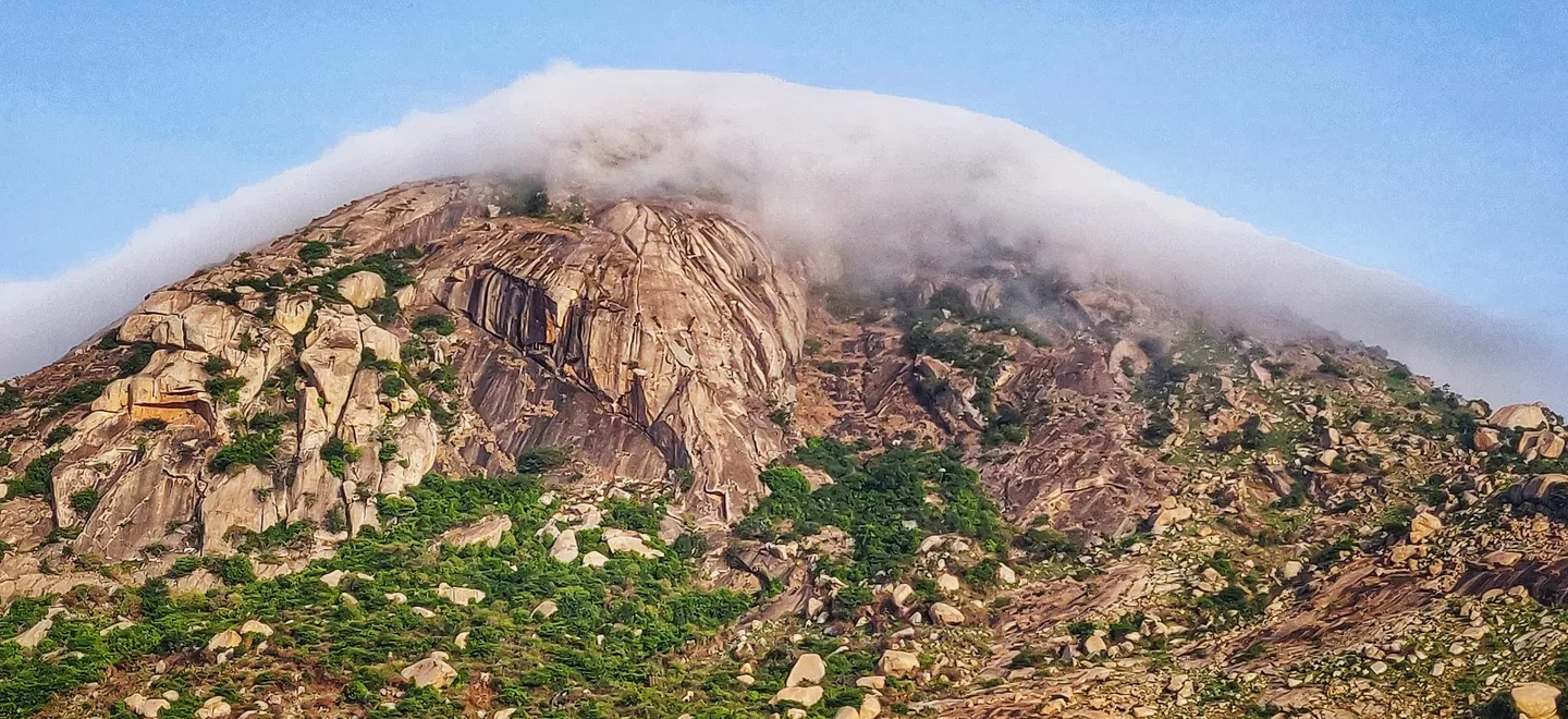
- The cloud sea, when it happens. IMD's Climate of Karnataka records that hill fog is frequent over the high ground of south interior Karnataka during the rainy months of June to September, which is when the hill most often stands above cloud.
- Muddenahalli, the birthplace of Sir M. Visvesvaraya and the place he was buried after his death in 1962. It is about 3 km from the trailhead on Indiahikes' own driving directions — 2 km from the Muddenahalli bus stop to the Kalawara T-junction, then 900 m — and it is where the photographer of this page's lead image was standing when he took it.
This is a short walk with a steep second half, so train for the climb rather than the distance. Indiahikes' own four-week guide for this trek is running — a 5 km jog in 45 minutes to begin with, building until you can do 5 km in 40 — or cycling 15 km in an hour building to 18, plus squats, lunges and planks for the legs and core. Footwear is the one place the usual advice is inverted: Indiahikes specifically recommends sports or running shoes with a good grip on slippery mud surfaces, and says trekking shoes with hard soles do not grip the slippery sections here. Carry all your water from the tank at the Papagni Mutt — Indiahikes says there is no water source except that one anywhere on the trek — and carry a headtorch with fresh cells if you are on an early start, because the first hour is in the dark and the trail is rock and loose mud, not steps.
- You cannot walk up without a ticket. Booking is online and in advance through the Forest Department, and the department runs checking squads against people who go up without one. Trespassing in a reserved forest is an offence: Deccan Herald reported in April 2026 that it is non-cognisable and carries a maximum of a Rs 500 fine or six months in prison.
- Whether a night start is allowed is genuinely contested right now, so ask before you drive out at midnight. Indiahikes answers it flatly — asked whether the trek can be done during the night, it says no, you cannot; Karnataka Tourism's page, last reviewed on 3 September 2026, still describes a midnight hike and calls a headlamp or torch a must for the night trek; Wikipedia, citing the department's own trek page, describes starts at 4 am and 8 am capped at 150 people each.
- Availability is switched on and off route by route, and on 7 September 2026 this route was off. The Aranya Vihaara portal offered treks in only four districts — Bengaluru Rural, Chikkamagaluru, Dakshina Kannada and Kalaburagi — thirteen trails in all, and Skandagiri was not one of them. The reason has moved on twice since the April 2026 fire-season pause: state-wide circulars of 11 May 2026 suspended trekking on wildlife-frequented routes and wherever the safety SOP is not certified, and the 30 August 2026 SOP reopens trails only after a route-wise assessment. The older karnatakaecotourism.com page for Skandagiri still loads and still shows a Book Now form, but it is the superseded portal — it carries a COVID-era notice about the trek timings and a booking calendar frozen in January 2022, and it is not where the department sells tickets. Check the portal, the KFD helpline 1926 or [email protected] before you commit to a date.
- Published altitudes disagree by about 100 m — roughly 1,350 m by the two Karnataka government pages, about 1,450 m by Wikipedia — and no survey figure settles it. It changes nothing about the walk, but do not quote the higher number as fact.
- Carry the original of the government photo ID you booked with. The portal's rules, effective 15 July 2026, make producing it on the day compulsory, and the guard at the check post records it before letting you through.
- There is no water and almost no shade above the mutt, and plastic bottles and bags are banned on Forest Department trails with a penalty for carrying them. Bring a refillable bottle, fill it at the tank, and expect direct sun the whole way up outside the early morning.
- Skandagiri is not Nandi Hills, and the two are not interchangeable. Nandi Hills is a drive-up hill station about 23 km away by road with its own separate entry rules; Skandagiri is a walk, on a ticket, with a forest check post at the bottom.
Kempegowda International Airport (BLR) is the nearest airport, about 38 km from Chikkaballapur, which makes it closer to the trailhead than the city is. Chikkaballapur (CBP) on the Yelahanka-Bangarpet line is the nearest railhead, with morning trains from Bengaluru. By road it is roughly 60 to 70 km from Bengaluru up NH-44, about an hour and a half by car, and buses run from Kempegowda (Majestic) bus station to Chikkaballapur every ten minutes or so. From Chikkaballapur take an auto-rickshaw the 3 km to the Papagni Mutt at Kalavara, which is where the walk starts and where you park; Indiahikes notes you can also walk it from the bus or train station. Chikkaballapur town is the last place for an ATM, a chemist and a proper meal; the nearest eateries to the base are the few small ones at Nandi Grama, at the foot of Nandi Hills.
- Sports or running shoes with a good grip on slippery mud — Indiahikes specifically advises these over trekking shoes with hard soles, because the failure mode here is a slip on wet rock or loose mud, not a twisted ankle on scree
- A headtorch with fresh cells and a spare set, if you are on an early slot; the first hour is in the dark
- At least 2 litres of water in a refillable bottle, filled at the tank by the Papagni Mutt — there is no water above it, and single-use plastic bottles are banned on the trail
- The original of the government photo ID used for the booking, plus the booking confirmation
- Sun hat or cap, sunglasses and SPF 50+; the trail has very little tree cover and the descent is usually in full sun
- A light windproof layer for the summit, which is exposed and can be cold and wet in fog before sunrise
- Food you carry in and carry out — there is nothing on the hill, and litter is what got this route closed before
- A small first-aid kit with blister cover and an elastic bandage, and any personal medication
- A charged phone; Indiahikes reports network for almost all major operators along the trek, with some sections where it is weak
Safety, verified
Safety details last verified 7 Sept 2026 by MadClub.
- Known hazardsVerified
A narrow section in the upper 900 m where Indiahikes warns that a slight misstep to your left will lead to a straight 100-foot drop, and then almost a 50-foot steep ascent on rock which it says turns very slippery, especially in the monsoons; loose mud and polished rock that slide underfoot, worst on the descent, where Indiahikes also warns the way markers are not easily visible and you may end up losing your way; darkness on the pre-dawn start, when the ground is rock and loose earth rather than steps; heat and full sun on a trail with very little tree cover, which IMD's hottest months of April and May make worse; no water source above the tank at the Papagni Mutt. The wider history is the warning: the route was closed around 2010 after accidents, trekking was still banned day and night in January 2016 when Deccan Herald found parties being turned back, and about 80 people who went up at night were taken to a police station in a trek Deccan Herald reported in May 2016.
- https://web.archive.org/web/20260223060503/https://indiahikes.com/documented-trek/skandagiri-trek
- https://www.deccanherald.com/india/karnataka/bengaluru/trekkers-surprised-by-ban-at-skandagiri-hills-502215.html
- https://www.deccanherald.com/content/547044/night-young.html
- https://www.deccanherald.com/india/karnataka/bengaluru/trek-to-skandagiri-savandurga-legally-from-jan-495529.html
- https://imdpune.gov.in/library/public/Climate%20of%20Karnataka.pdf
- Permits requiredVerified
A Karnataka Forest Department trekking ticket, booked online in advance — there is no walk-up entry and no on-the-spot registration. Bookings moved to aranyavihaara.karnataka.gov.in when the Forest Minister launched it on 3 October 2024 with Skandagiri among the first five trails; Karnataka Tourism's page still points at the older Karnataka Eco-Tourism site. Portal rules effective 15 July 2026: book at least a day ahead and no more than 30 days ahead, carry the original of the ID used at booking, 50% refund if cancelled 8 or more days out and none within 7 days. Skandagiri is not on sale today. On 7 September 2026 the portal's booking form offered treks in only four districts — Bengaluru Rural, Chikkamagaluru, Dakshina Kannada and Kalaburagi — and Chikkaballapur was not one of them; the portal carried thirteen active trails and Skandagiri was not among them. Two state-wide orders sit above that: circulars of 11 May 2026 from the PCCF (Wildlife) and Chief Wildlife Warden suspended trekking on forest routes frequented by wildlife until further orders and suspended trekking anywhere the safety SOP is not certified as met, and a Forest Department trekking SOP of 30 August 2026 requires a route-wise assessment before any trail reopens, with trails reopening individually as they are found ready. Do not plan a date until the trail is back on the portal; the helpline is 1926 and the trekking desk is [email protected]. Camping is not permitted and single-use plastic is banned on the trail.
- https://aranyavihaara.karnataka.gov.in/
- https://www.deccanherald.com/india/karnataka/trekking-resumes-in-karnataka-with-strict-rules-against-plastic-pollution-3218192
- https://www.deccanherald.com/india/karnataka/a-wild-goose-chase-for-forest-department-to-end-trekkers-jungle-raj-3966082
- https://aninews.in/news/national/general-news/karnataka-govt-suspends-trekking-in-forest-routes-after-10-year-old-killed-in-leopard-attack20260512235721/
- https://aninews.in/news/national/general-news/karnataka-forest-department-unveils-new-safety-framework-strict-sops-for-forest-treks20260830221229/
- https://newskarnataka.com/karnataka/aranya-vihaara-new-online-portal-for-regulated-trekking-in-karnataka/05102024/
- https://karnatakatourism.org/en/experiences/skandagiri-trek/
- https://karnatakaecotourism.com/treks/skandagiri
- https://web.archive.org/web/20260223060503/https://indiahikes.com/documented-trek/skandagiri-trek
- Best seasonVerified
Winter, which is what the state's own page recommends: Karnataka Tourism says that if you do not wish to trek during the night, winter is the best time to trek Skandagiri, that summers are harsh and should be avoided, and that the monsoon should be avoided because the rocks and the boulders become slippery. IMD's Climate of Karnataka names April and May the hottest months, when the weather turns very dry and uncomfortable, and this trail has almost no tree cover; the southwest monsoon runs from June to September. Indiahikes takes the other view — it calls Skandagiri one of those treks that can be done all year round — while still advising against trekking in heavy rain, so read winter as the comfortable window rather than the only one. The cloud sea the hill is known for is a monsoon and post-monsoon effect: IMD records hill fog as frequent over the high ground of south interior Karnataka from June to September. The clearest air and the best odds of cloud below you are therefore different seasons.
- Maximum altitudeVerified
Published figures disagree by about 100 m and we report the spread rather than choosing the flattering one: Karnataka Tourism gives 1,350 m / about 4,430 ft and the Forest Department's own Karnataka Eco-Tourism listing gave the same; Wikipedia gives about 1,450 m / 4,760 ft. We lead with 1,350 m as the state government figure. No survey figure was found to settle it. Indiahikes publishes no summit height and gives the climb instead — approximately 1,200 feet, about 365 m, of gain from the Papagni Mutt. Subtracting Wikipedia's uncited 915 m infobox figure for Chikkaballapur town from the two summit heights gives 435 m or 535 m instead, so treat the ascent as roughly 350 to 550 m.
- https://karnatakatourism.org/en/experiences/skandagiri-trek/
- https://en.wikipedia.org/wiki/Skandagiri
- https://web.archive.org/web/20220120191129/https://karnatakaecotourism.com/treks/skandagiri
- https://web.archive.org/web/20260223060503/https://indiahikes.com/documented-trek/skandagiri-trek
- https://en.wikipedia.org/wiki/Chikkaballapur
- Getting thereVerified
Kempegowda International Airport (BLR) is about 38 km from Chikkaballapur — closer to the hill than Bengaluru city is — and Chikkaballapur (CBP) on the Yelahanka-Bangarpet line is the nearest railhead, with morning trains from Bengaluru. By road the hill is roughly 60-70 km from Bengaluru up NH-44, about an hour and a half by car; published figures are less than 60 km (Indiahikes), 62 km (Wikipedia), 68 km (the Karnataka Eco-Tourism listing) and 70 km (Karnataka Tourism), with Wikipedia separately putting Chikkaballapur town 65 km from Bengaluru. Buses from Kempegowda (Majestic) bus station to Chikkaballapur run roughly every ten minutes. From Chikkaballapur it is 3 km by auto-rickshaw to the Papagni Mutt at Kalavara village, where the trail starts and where vehicles park; Indiahikes notes the 3 km can be walked from the bus or train station. Chikkaballapur town is the last ATM, chemist and full meal; the nearest eateries to the base are the few small ones at Nandi Grama, at the foot of Nandi Hills.
- https://en.wikipedia.org/wiki/Chikkaballapur
- https://karnatakatourism.org/en/experiences/skandagiri-trek/
- https://en.wikipedia.org/wiki/Skandagiri
- https://web.archive.org/web/20220120191129/https://karnatakaecotourism.com/treks/skandagiri
- https://web.archive.org/web/20260223060503/https://indiahikes.com/documented-trek/skandagiri-trek
- https://www.census2011.co.in/data/village/623551-kalavara-karnataka.html
- Difficulty noteVerified
Moderate, and short. The distance is disputed and we print both figures: Karnataka Tourism and the Forest Department's Karnataka Eco-Tourism listing both give about 8 km — the Eco-Tourism card's own info block gives a length of 4 km, the same figure one way — while the section table published by Indiahikes and by Wikipedia gives 800 m from the Papagni Mutt to the forest check post, 1,100 m to the rest point and 900 m to the summit, i.e. 2.8 km each way and 5.6 km there and back. We lead with the government's 8 km and print the sections so the gap is visible. Two to three hours up; the whole outing is about five hours on Indiahikes' and Wikipedia's figures, six to eight hours for the full circuit on Karnataka Tourism's. Karnataka Tourism grades it moderate; the department's Karnataka Eco-Tourism listing graded it moderate and called the walk moderate to tough in the same sentence that gives the 8 km; Wikipedia calls it moderately challenging; Indiahikes grades it Easy, and says so consistently. The three government-side gradings say moderate, which is what we lead with. The difficulty is concentrated in the last 900 m: steep uneven rock, loose mud, a narrow stretch with a straight 100-foot drop on one side, and almost a 50-foot steep ascent on rock.
- Safety equipmentVerified
Sports or running shoes with a good grip on slippery mud surfaces rather than hard-soled trekking shoes — Indiahikes is explicit that hard soles do not provide good grip on the slippery sections here. A headtorch with spare cells for an early start, a minimum of 2 litres of water in a refillable bottle filled at the Papagni Mutt tank (single-use plastic bottles are banned on Forest Department trails), sun hat, sunglasses and SPF 50+ for a route with almost no shade, a light windproof layer for a cold, foggy summit before sunrise, and a small first-aid kit. Carry the original photo ID used at booking; the guard at the check post enters your details in the register. Sharp metal objects, weapons, noise-making equipment and campfires are prohibited under the 2026 procedure.
- https://web.archive.org/web/20260223060503/https://indiahikes.com/documented-trek/skandagiri-trek
- https://www.deccanherald.com/india/karnataka/following-recent-incidents-karnataka-rolls-out-trekking-sop-with-mandatory-guides-gps-tracking-3971081
- https://www.deccanherald.com/india/karnataka/trekking-resumes-in-karnataka-with-strict-rules-against-plastic-pollution-3218192
- Guide requirementVerified
Mandatory under the Forest Department's standard operating procedure announced by Minister Eshwar Khandre on 17 April 2026 and issued as a circular by the Principal Chief Conservator of Forests (Head of Forest Force) on 18 April 2026: one nature guide per ten trekkers, a maximum of 150 people on a trail, and a guide provided even where a single trekker has registered. Guides carry a GPS-enabled walkie-talkie, keep no trekker ahead of them, count heads at the base camp and rest points and check in with the base every thirty minutes, and the base camp raises the alarm if a guide goes quiet for an hour. Trekkers are required to use a tracking app, and minors need a parent's consent. The procedure is live rather than aspirational: a PCCF (Wildlife) circular of 11 May 2026 suspends trekking outright wherever its conditions are not met and certified, and the 30 August 2026 SOP restates trained local escorts and GPS tracking as conditions of reopening a route. Navigationally, Indiahikes says the trail to the fort is about as straightforward as it can get and does not recommend a guide, but the rule stands regardless.
- https://www.deccanherald.com/india/karnataka/following-recent-incidents-karnataka-rolls-out-trekking-sop-with-mandatory-guides-gps-tracking-3971081
- https://aninews.in/news/national/general-news/karnataka-govt-suspends-trekking-in-forest-routes-after-10-year-old-killed-in-leopard-attack20260512235721/
- https://aninews.in/news/national/general-news/karnataka-forest-department-unveils-new-safety-framework-strict-sops-for-forest-treks20260830221229/
- https://aranyavihaara.karnataka.gov.in/
- https://web.archive.org/web/20260223060503/https://indiahikes.com/documented-trek/skandagiri-trek
- Emergency protocolVerified
Short and, by hill standards, benign: the summit is about two hours above a manned Forest Department check post and a road, and Indiahikes reports network for almost all major operators — Airtel, Vodafone and Jio — throughout the trek, except for some sections where it is weak. Under the 2026 procedure the guide carries a first-aid kit and a GPS-enabled walkie-talkie and reports to the base camp every thirty minutes, and base camp staff make contact if an hour passes in silence. Distances matter here: the trailhead is 3 km from Chikkaballapur, the district headquarters, and the District Hospital on APMC Road is listed on the district administration site, but the hospital Indiahikes names as the closest is the New Government Multi Speciality Hospital 12 km away, on 081562 72388 — so plan an evacuation around 12 km, not 3. Indiahikes gives the nearest police station as Chikballapur Town on 081562 74000 and the national emergency number as 112, and puts the nearest ATM 5 to 6 km from the base. The Forest Department helpline is 1926 and the trekking desk is [email protected]. The realistic emergency here is a fall on the steep upper section, so walk the narrow stretch and the rock step deliberately rather than quickly.
- https://www.deccanherald.com/india/karnataka/following-recent-incidents-karnataka-rolls-out-trekking-sop-with-mandatory-guides-gps-tracking-3971081
- https://web.archive.org/web/20260223060503/https://indiahikes.com/documented-trek/skandagiri-trek
- https://aranyavihaara.karnataka.gov.in/
- https://aranya.gov.in/
- https://chikkaballapur.nic.in/en/public-utility-category/hospitals/
- Fitness prerequisiteVerified
A reasonable first hill walk for anyone with everyday fitness: Indiahikes says a person who follows an active lifestyle can consider Skandagiri as their first trek, and recommends a bit of preparation for anyone who leads a relatively sedentary life. Its own four-week guide for this trek is a 5 km jog in 45 minutes building to 5 km in 40, or cycling 15 km in an hour building to 18, plus squats, lunges and planks. The gradient is the work, not the distance: about 1,200 ft, roughly 365 m, of gain from the Papagni Mutt on Indiahikes' figure, or 435 to 535 m if you subtract Chikkaballapur town's published elevation from the two summit heights. Indiahikes grades the walk easy and calls it one of the ideal treks to introduce kids above 8 years old to trekking; the department's own Karnataka Eco-Tourism listing was marked Not for children and the 2026 procedure requires a parent's consent for minors, so confirm at booking if you are bringing one.
- https://web.archive.org/web/20260223060503/https://indiahikes.com/documented-trek/skandagiri-trek
- https://web.archive.org/web/20220120191129/https://karnatakaecotourism.com/treks/skandagiri
- https://www.deccanherald.com/india/karnataka/following-recent-incidents-karnataka-rolls-out-trekking-sop-with-mandatory-guides-gps-tracking-3971081
Payment protected — held until your trip starts.
Safety details & FAQ
Do I need a permit for Skandagiri, and can I just turn up?
You need a Forest Department ticket booked in advance, you cannot turn up — and as of 7 September 2026 the department is not selling one for this trail, so the honest answer is that you cannot legally do this walk today. Since 3 October 2024 the department's trekking bookings run through aranyavihaara.karnataka.gov.in, which was launched with Skandagiri as one of its first five trails; Karnataka Tourism's own page still routes bookings to the older Karnataka Eco-Tourism site. News Karnataka reported at launch that booking runs on an email registration, a government ID and an OTP, and the portal's rules effective 15 July 2026 require you to carry the original of that ID on the day. Turning up without a ticket is a forest offence carrying up to a Rs 500 fine or six months in prison. The trail is expected back: the 30 August 2026 SOP reopens routes one at a time as each is assessed, and the first reopenings went to the Kudremukh Wildlife Division. Watch the portal rather than a blog.
Is the night trek to Skandagiri allowed?
This is the one thing to check before you leave home, because reputable sources disagree. Indiahikes says plainly that you cannot do the Skandagiri trek during the night. Karnataka Tourism's page, last reviewed on 3 September 2026, still describes a midnight hike and lists a headlamp as a must for the night trek, and Wikipedia, citing the department's trek page, describes starts at 4 am and 8 am. What is not in doubt is the history: the hill was closed to trekking day and night in 2016, and about 80 people who went up at night were taken to a police station in a trek Deccan Herald reported in May 2016. Confirm the current start time on the booking portal or with the Chikkaballapur forest office rather than with a blog.
How high is Skandagiri, and how long does it take?
Sources disagree on the height by about 100 m. Karnataka Tourism and the Forest Department's Karnataka Eco-Tourism listing both say about 1,350 m; Wikipedia says about 1,450 m. We lead with 1,350 m because it is the figure the state's own pages carry, and we would rather print the spread than pick one. The distance is disputed the same way. Both government pages say about 8 km — the Eco-Tourism card's own info block gives a length of 4 km, which is the same figure one way — while the three-section table published by Indiahikes and by Wikipedia gives 800 m from the mutt to the check post, 1,100 m to the rest point and 900 m to the summit, or 2.8 km each way and 5.6 km there and back. We lead with the government's 8 km. It is two to three hours up, and the whole outing is about five hours on both Indiahikes' and Wikipedia's figures, or six to eight on Karnataka Tourism's for the full circuit.
Who built the fort at the top?
It is attributed to Tipu Sultan, and honestly that is where the evidence stops. Karnataka Tourism states the fortress was built by Tipu Sultan and abandoned from 1791; Wikipedia says the ruins are believed to have been built by Tipu; the British Library, in its caption to a 1794 aquatint of the hill, calls it Tipu's fort, describes it as a small but strong hill fort, and says it surrendered to British troops on 19 October 1791. Treat that date as attributed rather than established: it rests on one catalogue caption whose original British Library page is gone, and it is the same day the much larger Nandidurg fell to Cornwallis, which is exactly the shape a conflation takes. No source we found gives a construction date or cites an archaeological survey, and hill forts in this group are much older than Tipu: the Nandi Hills fortress is credited to the Ganga dynasty. Treat the fort as eighteenth-century in its surviving form and the builder as an attribution.
When is the best time to go?
Winter, on the state's own advice. Karnataka Tourism says that if you do not wish to trek during the night, winter is the best time to trek Skandagiri, that summers are harsh and should be avoided, and that the monsoon should be avoided because the rocks and boulders become slippery. IMD's Climate of Karnataka puts the hottest months at April and May, when it notes the weather turns very dry and uncomfortable across the state, and this trail has very little tree cover. Indiahikes takes the other view and calls Skandagiri one of those treks that can be done all year round, while still advising against trekking in heavy rain. One thing to weigh: the famous sea of clouds is a monsoon and post-monsoon effect rather than a winter one — IMD records hill fog as frequent over high ground in south interior Karnataka from June to September — so the clearest air and the best odds of cloud below you are not the same months.
Do I need a guide?
Under the standard operating procedure announced by the Forest Minister on 17 April 2026, and issued as a circular by the Principal Chief Conservator of Forests on 18 April 2026, a nature guide is mandatory at one per ten trekkers on trails under the department, and the minister said a guide would be provided even for a single registered trekker. Guides carry a GPS-enabled walkie-talkie, keep no trekker ahead of them, count heads at the base and rest points and check in with the base camp every thirty minutes. Indiahikes separately says the trail to the fort is about as straightforward as it can get and does not recommend a guide for it — but the rule is the rule, and Indiahikes also warns that on the way down the way markers are not easily visible and you may end up losing your way.
Is this a good first hill walk, and can children do it?
For a fit beginner, yes: it is short, it is close to Bengaluru, there is a check post at the bottom and mobile coverage most of the way. Indiahikes says a person who follows an active lifestyle can consider Skandagiri as their first trek. It is not effortless — the last 900 m are steep, there is a narrow stretch where Indiahikes warns that a slight misstep to your left leads to a straight 100-foot drop, and then almost a 50-foot steep ascent on rock which it says turns very slippery, especially in the monsoons. On children the sources conflict: Indiahikes grades the walk easy and calls it one of the ideal treks to introduce kids above 8 years old to trekking, while the department's own Karnataka Eco-Tourism listing was marked Not for children, and the 2026 procedure requires a parent's consent for minors. Confirm at booking.
What's included
- Karnataka Forest Department trekking tickets for the group, booked in advance on the Aranya Vihaara portal.
- A Forest Department nature guide with the group for the whole walk.
- A trek leader from Elegant Adventurers.
- Breakfast after the walk at a local place near Kalavara.
- First-aid kit and a pulse oximeter carried by the leader.
What's not included
- Travel between Bengaluru and Kalavara. Arrange your own vehicle or ask us to add you to a shared cab.
- Meals other than the breakfast listed above, and all drinks and snacks on the hill.
- Personal gear, including footwear with grip, a rain layer and at least two litres of water.
- Anything the Forest Department charges over and above the trekking ticket, such as a camera fee.
- Personal insurance and evacuation costs.
Day-by-day itinerary
Papagni Mutt to the Skandagiri summit and back. About 8 km round trip, 4 to 5 hours of walking. Gate formalities and a briefing at 6:00 AM, on the trail by 6:30, at the fort and the Shiva temple by mid-morning, back at the base by about noon. Breakfast is at a local place afterwards and the group is back in Bengaluru by late afternoon.
Reviews
Safety details last verified 7 Sept 2026