Dates & prices
No upcoming dates yet.
This operator hasn't scheduled new dates for this trip.
About Savandurga Hike
Everything from the adventure page, so you do not have to leave this trip.
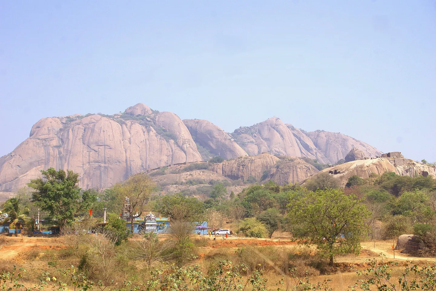
A half-day walk up the bare granite dome of Savandurga, about 60 km west of Bengaluru off the Magadi road. Two to three hours up on open rock with no shade and no water, through two lines of old fort wall to a stone Nandi at the top.
Trip details
Savandurga is a granite hill about 60 km west of Bengaluru (Bangalore), off the Magadi road, and it is the nearest thing to a mountain day that the city has. Wikipedia and the district administration both put the top at 1,226 m above mean sea level, which Wikipedia converts to 4,022 ft; Karnataka Tourism and Deccan Herald give 4,024 ft, which is the same number rounded a different way rather than a real disagreement. It is really two hills, split by a chasm: Karigudda, the black hill, heaped with boulders and shrub, and Biligudda, the white hill, whose bare slope is the one people walk. You will read everywhere that it is the largest monolith hill in Asia — the district's own tourism page says so in as many words — but no geological or survey source we could find supports it, so treat it as local shorthand for very big rather than as a measured fact. The walk starts behind the Sri Lakshmi Narasimhaswamy temple, where the road ends, and it is on rock within minutes. A short scrub trail reaches the foot of the dome, and from there almost the whole climb is open granite at a steady angle, with a faint polished line and painted marks standing in for a path. Two lines of old fortification cross the route. Savandurga was the secondary capital of the Magadi rulers, of whom Kempe Gowda is the best known, and it later passed to Mysore; East India Company forces under Cornwallis stormed it on 22 December 1791, after a twenty-day siege in the Third Anglo-Mysore War, from a fort that had been thought virtually impregnable. Above the second wall the ground eases into boulders and dry deciduous forest, then a last set of slabs, then a whitewashed pavilion with a stone Nandi in it. Two to three hours up, about two down. What is hard here is not height. Nothing on this hill is high enough to make you ill, and the day is decided by angle, grip and heat instead. Wikipedia gives the easiest way up as the South-Side route and says the climbing lines on this face mostly face south or are exposed to the south-east, so that the rock becomes hot once the sun comes up; IMD's Ramanagara chapter, which reads its temperatures off the Bengaluru airport observatory because the district has no observatory of its own, puts April's mean daily maximum near 34°C with some days above 37°C. There is no water on the route and no shade once you are off the scrub trail at the bottom, which Bikat puts at about twenty minutes from the temple. People get lost here and people have died here: Deccan Herald reported eleven trekkers stranded on the hill in a July 2016 downpour after they lost the route, and in December 2023 a man who had gone up with a friend was reported missing and found dead in a ditch after a search of roughly 100 hours by Magadi police, forest staff and the SDRF. Start before first light, stay together, and turn back rather than invent a line down.
- The Savandi Veerabhadreshwara Swamy temple at the foot of the hill, whose 70-foot deepasthambha carries carved figures on the faces of its square base: Daksha with folded hands on the side facing the temple, and Bhairava, Daksha's consort and Nandi on the others. Deccan Herald records that the temple serves free food to devotees every day.
- The Sri Lakshmi Narasimhaswamy temple, said to date from the 17th century, whose sanctum is a cave in the rock. This is where the road ends and the walking starts — the trail goes up from behind it.
- The first fort wall, about a hundred metres up the initial rock slope. Karnataka Tourism attributes the ruined fortifications here to Kempe Gowda, Tipu Sultan and the other rulers who held the hill in turn, and sources disagree on the seventeenth- and eighteenth-century dates; what is firm is that Cornwallis stormed the place on 22 December 1791.
- Biligudda's open granite, which is the walk. The angle is steady rather than stepped for most of its length — Bikat notes indentations in the rock that give some grip, and Deccan Herald's account describes one steeper rock with steps cut into it higher up — and the route is marked by a worn line and painted daubs rather than by cairns or signs, with nothing to hold on to.
- A stone mantapa, a small pillared pavilion of granite slabs standing on open rock, which Deccan Herald's account reaches beyond a watch tower higher up the slope.
- The dhone — a pool of rainwater weathered into a depression in the granite, which Deccan Herald's account of the route found near the mantapa. Bikat's guide says there are no reliable water sources on the trail, so it is a thing to look at rather than to drink.
- The Nandi at the top, a dark stone bull carved with bell-garlands under a whitewashed pillared pavilion. This is the summit marker; there is no plaque and no view indicator.
- Manchanabele reservoir and, further off, Thippagondanahalli reservoir — both on the Arkavathi — with the Bengaluru plain running east and Karigudda's boulder slope across the chasm.
- Butterflies. Wikipedia's own gallery for this hill carries photographs of the golden angle, common three-ring, grass jewel and common lineblue taken here, and the surrounding state forest is recorded as holding sloth bear and leopard.
Train for the descent, not the ascent. Going up is a long steady effort that most reasonably fit people can manage in two to three hours; coming down a long unbroken slope of smooth granite is where knees, ankles and nerve give out, and it is where people slip. Build to four or five sessions a week of brisk walking or running, and add stair or slope repeats going DOWN as well as up, plus single-leg and calf work. Break in footwear with a genuinely soft, grippy sole — smooth granite punishes hard-soled boots and worn trainers equally. Then plan the day around heat rather than fitness: leave Bengaluru around 4 am so you are on the rock before sunrise, carry at least two litres per person because there is no water and no shop on the hill, and accept that by nine or ten in the morning the rock is radiating and the sensible thing is to already be walking down.
- The rules for entering this hill have changed repeatedly and are not published anywhere reliable. Forest Department permission has been required at least since 2016; the department shut every Karnataka trekking route without online booking in January 2024, reopened a handful on the Aranya Vihaara portal in October 2024, and had booking disabled again for the fire season in April 2026. Since 11 May 2026 a state-wide suspension has applied to forest routes frequented by wildlife, and a trekking SOP of 30 August 2026 reopens trails only one at a time after a route-wise assessment. On 7 September 2026 that portal's booking form offered treks in four districts and this one was not among them. Ask the Forest Department before you drive out — the portal gives 1926 as its helpline and [email protected] as its trekking desk. No source we could find describes a manned check post at the base, so do not count on getting permission on the day; carry photo ID and cash if you go, and be ready to be turned away.
- Only Biligudda, the white hill, is the walking route. Karigudda is boulder and shrub with no marked line, and the bolted rock-climbing routes on the south face are a different activity needing rope, a partner and experience.
- There is no water on the hill and no reliable food at the base — a few snack stalls, no restaurant. Carry everything, including what you will want on the way down.
- Mobile coverage is dependable at the base and patchy to absent on the rock. Tell somebody your plan and your expected time back, and keep the group together. Deccan Herald's account of the July 2016 rescue is of eleven people who lost the route together in a downpour, and the same report records an earlier group of night trekkers who strayed onto the hill and could not find their way back.
- Karnataka Tourism's own advice is to be off the top before dark, because the surrounding forest holds sloth bear and leopard. Descending this rock in the dark is the more immediate reason.
- Ramanagara district was formally renamed Bengaluru South district on 23 May 2025. Both names are in live use on maps, addresses and signboards, and the district headquarters is still the town of Ramanagara. Do not read Bengaluru South as meaning the hill is inside the city — it is 60 km outside it.
- This is a place of worship as well as a hill. The two base temples draw pilgrims from across south Karnataka, the summit Nandi is an active shrine, and the prehistoric site on the hill — the megalithic cemetery Branfill described in print in 1881 — is centrally protected by the ASI as monument N-KA-B8.
Savandurga is best reached by car. Published distances from Bengaluru range from 50 km to 60 km — Karnataka Tourism and the district administration both say 50 km, Deccan Herald and Wikipedia both say 60 km — and neither figure is tied by its source to a particular road. There are two roads. The Magadi road route runs west out of Bengaluru and turns left at Magadi cross, roughly 48 km out; the Mysuru road route goes via the Big Banyan tree and Manchanabele dam and is the one Deccan Herald recommends. Either way it is 90 minutes to two hours in normal traffic and rather less at four in the morning. Karnataka Tourism puts both Magadi town and Manchanabele dam 13 km from the hill. On public transport, buses run from Kempegowda (Majestic) bus station to Magadi every half hour or so for about ₹15-20, taking an hour to an hour and a half, and shared autos run from Magadi to the temple at the base. Karnataka Tourism gives Bidadi, 30 km away, as the nearest railway station and Kempegowda International Airport, about 90 km, as the nearest airport; Ramanagara, about 30 km, is where the district hospital is.
- Shoes with a soft, grippy sole and plenty of tread left — this is the single thing that decides how the descent goes. Worn trainers and hard-soled boots both slide on polished granite.
- At least 2 litres of water per person, and more in the hot months; there is none on the hill
- Headlamp or torch, because the sensible start is before sunrise
- Sun hat, sunglasses and SPF 50+ — there is no shade above the first twenty minutes and the rock reflects
- Food for the whole outing, since there is no restaurant at the base and nothing on the route
- Government photo ID in the original; the Forest Department patrols this hill, and permission is what you are relying on to be on it
- A small first-aid kit with blister cover, crepe bandage and painkillers
- Cash in small notes for parking, the shared auto and whatever fee you are asked for — no official figure is published
- A rain shell and a pack cover if you go anywhere near the monsoon or post-monsoon months, though wet rock here is a reason not to go at all
Safety, verified
Safety details last verified 7 Sept 2026 by MadClub.
- Known hazardsVerified
Falls on bare granite, which is the hazard that has actually hurt people here — the slope is continuous and a slip slides rather than stops, and the descent is worse than the ascent. Heat and dehydration: the walking line goes up the south side, which Wikipedia says becomes quite hot once the sun comes up, and there is no shade above the first twenty minutes and no water anywhere on the hill. Rain-slick rock, which is why the monsoon and retreating-monsoon months are not walking months; eleven trekkers were stranded here in a July 2016 downpour after losing the route. Losing the way above the second fort wall, where the line crosses boulders and forest without signage. Patchy to absent mobile coverage on the rock. Sloth bear and leopard in the surrounding state forest, which is Karnataka Tourism's stated reason for not being on the hill after dark. In December 2023 a man who had gone up with a friend was reported missing and found dead in a ditch on the hill after a roughly 100-hour search by Magadi police, forest staff and the SDRF.
- https://www.deccanherald.com/content/558586/11-trekkers-rescued-savandurga.html
- https://newsable.asianetnews.com/india/karnataka-up-based-bengaluru-trekker-found-dead-at-savandurga-hills-after-100-hour-search-efforts-vkp-s6dh38
- https://web.archive.org/web/20250213104557/https://www.karnatakatourism.org/tour-item/savanadurga/
- https://en.wikipedia.org/wiki/Savandurga
- https://deccanherald.com/metrolife/metrolife-your-bond-with-bengaluru/dont-trek-in-prohibited-terrain-say-outdoor-experts-1084847.html
- Permits requiredVerified
Forest Department permission, and the current position is genuinely unsettled — check before you travel. The hill lies in Savanadurga State Forest; Deccan Herald's July 2016 report of a rescue here states that under Section 26(1)(d) of the Indian Forest Act any trespassing, including trekking or climbing, is prohibited and prior permission from the department is needed, and that the eleven rescued were warned under the Karnataka Forest Act. State-wide, the department ordered every trekking route without online booking shut on 30 January 2024 and reopened five of 23 routes on the Aranya Vihaara portal on 3 October 2024, with a cap of 300 trekkers a day that the April 2026 procedure has since replaced with 150 on a trail. Slot booking was disabled for the fire season as of 13 April 2026; on 11 May 2026 the PCCF (Wildlife) and Chief Wildlife Warden suspended trekking on forest routes frequented by leopards, tigers, elephants and bears until further orders, and in a second circular of the same date suspended trekking anywhere the safety SOP cannot be fully complied with until an officer certifies compliance; and a Forest Department trekking SOP of 30 August 2026 requires route-wise assessments before trails reopen to the public. The May wildlife circular was addressed to the tiger reserves and to the deputy conservators of all wildlife divisions, and this hill sits in a territorial division, so whether it bites here is not published. On 7 September 2026 the portal's booking form listed treks in only four districts — Bengaluru Rural, Chikkamagaluru, Dakshina Kannada and Kalaburagi — and there was no online slot for this hill. We could not verify a current official entry fee from any government source and will not publish a figure we cannot trace. Ask the department before you travel, on the portal's helpline 1926 or at [email protected]; no source we could find describes a manned check post at the base, so do not count on getting permission on the day. Carry government photo ID and cash if you go.
- https://www.deccanherald.com/content/558586/11-trekkers-rescued-savandurga.html
- https://www.deccanherald.com/india/karnataka/offline-trekking-routes-in-karnataka-shut-for-visitors-till-forest-dept-brings-regulation-2871428
- https://www.deccanherald.com/india/karnataka/trekking-resumes-in-karnataka-with-strict-rules-against-plastic-pollution-3218192
- https://www.deccanherald.com/india/karnataka/a-wild-goose-chase-for-forest-department-to-end-trekkers-jungle-raj-3966082
- https://www.deccanherald.com/india/karnataka/following-recent-incidents-karnataka-rolls-out-trekking-sop-with-mandatory-guides-gps-tracking-3971081
- https://aninews.in/news/national/general-news/karnataka-govt-suspends-trekking-in-forest-routes-after-10-year-old-killed-in-leopard-attack20260512235721/
- https://aninews.in/news/national/general-news/karnataka-forest-department-unveils-new-safety-framework-strict-sops-for-forest-treks20260830221229/
- https://aranyavihaara.karnataka.gov.in/
- Best seasonVerified
November to February. IMD's Ramanagara district climatology (rainfall normals 1971-2020, other parameters 1991-2020) makes December to February the dry season with clear bright weather, March to May the hot season with April's mean daily maximum near 34°C and some days above 37°C, June to September the southwest monsoon and October to November the retreating monsoon. IMD states in that chapter that the district has no meteorological observatory of its own and that its temperature description is taken from the Bengaluru Aero observatory at 901 m — about 325 m below this summit — so read the temperature figures as the city's rather than the hill's. September is the rainiest month — a district normal of 173.7 mm, and 216.7 mm at the Magadi gauge 13 km away — with October close behind at 192.2 mm at Magadi, so October is wetter than the common 'October to February' advice implies. Start before sunrise in any month.
- Maximum altitudeVerified
About 1,226 m / 4,022 ft at the top of Biligudda. Wikipedia and the Bengaluru South (formerly Ramanagara) district administration both give 1,226 m; Karnataka Tourism and Deccan Herald give 4,024 ft, which is 1,226.5 m — the same figure rounded differently rather than a genuine disagreement. Altitude is not a factor on this hike; nothing here is high enough to cause altitude sickness, and the difficulty is angle, grip and heat.
- Getting thereVerified
About 60 km west of Bengaluru off the Magadi road by Deccan Herald's and Wikipedia's reckoning, or 50 km by Karnataka Tourism's and the district administration's — neither source ties its figure to a particular road, so the spread is published as a spread rather than explained away. By car, either turn left at Magadi cross about 48 km out of the city, or go via the Big Banyan tree and Manchanabele dam, which Deccan Herald recommends; 90 minutes to two hours either way. Buses run from Kempegowda (Majestic) bus station to Magadi every half hour or so, about ₹15-20 and one to one and a half hours, with shared autos onward from Magadi. Nearest railway station is Bidadi, 30 km; nearest airport Kempegowda International, about 90 km. Magadi town and Manchanabele dam are 13 km away; Ramanagara, about 30 km, has the district hospital.
- https://web.archive.org/web/20250213104557/https://www.karnatakatourism.org/tour-item/savanadurga/
- https://www.deccanherald.com/india/karnataka/scenic-retreat-rocky-hill-2086220
- https://en.wikipedia.org/wiki/Savandurga
- https://bengalurusouth.nic.in/en/adventure/
- https://www.bikatadventures.com/home/blog/diy-guide-to-savandurga-trek
- Difficulty noteVerified
Moderate, graded on terrain rather than distance or height. Roughly two to three hours up and two down, but almost all of it is on open granite at a steady angle with no built steps or railing for most of its length and nothing to hold; Deccan Herald's account describes one steeper rock with steps cut into it higher up, and Bikat notes indentations in the rock that give some grip. The route is marked by a worn line and painted daubs rather than signs. The descent is the harder half and is where slips happen. Karnataka Tourism's own wording is that climbing the steep rocks 'requires extreme care and good fitness'. Bikat Adventures rates it their easiest level and still answers 'no' to whether it suits a beginner.
- https://web.archive.org/web/20250213104557/https://www.karnatakatourism.org/tour-item/savanadurga/
- https://www.bikatadventures.com/home/blog/diy-guide-to-savandurga-trek
- https://deccanherald.com/metrolife/metrolife-your-bond-with-bengaluru/dont-trek-in-prohibited-terrain-say-outdoor-experts-1084847.html
- Safety equipmentVerified
Footwear with a soft, grippy, unworn sole is the safety equipment on this hike — hard-soled boots and bald trainers both slide on polished granite. Beyond that: at least 2 litres of water per person because there is none on the hill, a headlamp or torch for the pre-dawn start, sun hat, sunglasses and SPF 50+ for a shadeless south-facing slope, food for the whole outing, a small first-aid kit with blister cover and a crepe bandage, and a charged phone knowing the signal is patchy. No rope, helmet or technical kit is needed on the Biligudda walking route; the bolted climbing routes on the south face are a separate activity with separate requirements.
- Guide requirementVerified
No guide requirement specific to this hill is published by any source we could find, and in practice most people walk it unaccompanied — but a guide is not optional on department trails any more. The Forest Minister announced a trekking standard operating procedure on 17 April 2026, issued as a circular by the PCCF (Head of Forest Force) on 18 April 2026, which makes a nature guide mandatory at one per ten trekkers on trails under the Forest Department's jurisdiction, with a maximum of 150 people on a trail and a guide provided even where only one trekker has registered. The SOP of 30 August 2026 adds locally trained people to accompany trekking groups, daily entry limits and GPS-enabled tracking. Neither names this hill and no route-specific requirement for Savandurga is published, but take the guide where one is offered rather than treating it as a nicety. The documented incidents here are the shape a guide exists to prevent: eleven trekkers who lost the route in a July 2016 downpour, and a man who went missing in December 2023 while walking with a friend.
- https://www.deccanherald.com/india/karnataka/following-recent-incidents-karnataka-rolls-out-trekking-sop-with-mandatory-guides-gps-tracking-3971081
- https://aninews.in/news/national/general-news/karnataka-govt-suspends-trekking-in-forest-routes-after-10-year-old-killed-in-leopard-attack20260512235721/
- https://aninews.in/news/national/general-news/karnataka-forest-department-unveils-new-safety-framework-strict-sops-for-forest-treks20260830221229/
- https://www.deccanherald.com/content/558586/11-trekkers-rescued-savandurga.html
- https://newsable.asianetnews.com/india/karnataka-up-based-bengaluru-trekker-found-dead-at-savandurga-hills-after-100-hour-search-efforts-vkp-s6dh38
- Emergency protocolVerified
Self-rescue means walking back down the same rock, which is exactly what an injured person cannot do — plan not to need it. Magadi police station, 13 km away, is the station that has handled the incidents on this hill, working with forest staff and the State Disaster Response Force; the district administration lists one hospital for the district, the District Hospital at Ramanagara, about 30 km away. Coverage is dependable at the base and patchy on the rock, so leave your plan and expected return time with someone at home before you start. If you lose the route, stop where you are and make yourself audible rather than descending an unknown slope.
- https://newsable.asianetnews.com/india/karnataka-up-based-bengaluru-trekker-found-dead-at-savandurga-hills-after-100-hour-search-efforts-vkp-s6dh38
- https://www.deccanherald.com/content/558586/11-trekkers-rescued-savandurga.html
- https://bengalurusouth.nic.in/en/public-utility-category/hospitals/
- https://web.archive.org/web/20250213104557/https://www.karnatakatourism.org/tour-item/savanadurga/
- Fitness prerequisiteVerified
Four to six hours of continuous effort on rock, including two hours of steep descent. No prior trekking experience is required, but sound knees and ankles and a head for exposed slopes are, and this is not a hill to bring an unfit or unwilling person to — turning back from halfway is easy, being talked down from three-quarters is not. Train four or five sessions a week of brisk walking or running for six to eight weeks and include downhill repeats and single-leg work, since the descent is what actually breaks people here. Children and anyone uneasy on open slopes should do a stepped hill such as Ramadevarabetta first.
- https://web.archive.org/web/20250213104557/https://www.karnatakatourism.org/tour-item/savanadurga/
- https://www.bikatadventures.com/home/blog/diy-guide-to-savandurga-trek
- https://deccanherald.com/metrolife/metrolife-your-bond-with-bengaluru/dont-trek-in-prohibited-terrain-say-outdoor-experts-1084847.html
Payment protected — held until your trip starts.
Safety details & FAQ
Is Savandurga really the largest monolith in Asia?
That is what almost every page about it says, including the Bengaluru South district administration's own adventure page, which states it plainly. We have not been able to trace the claim to any geological survey, government measurement or peer-reviewed source — Wikipedia's footnote for it points at a private tourism website. Deccan Herald, writing about the same hill, called it 'one of the largest monoliths of Karnataka', which is the safer wording. It is a very large granite inselberg and it is unquestionably the biggest thing near Bengaluru; beyond that we would not go.
How hard is it, honestly?
Moderate, and harder than a first-timer expects. It is only about two to three hours up and two down, with no altitude to speak of, but almost the whole of it is on open granite at a steady angle with nothing to hold. The descent is the difficult half: it puts everything into knees and ankles, and a slip runs. Gaurav J, who founded the Bengaluru climbing outfit Let's Play Climbing, told Deccan Herald in 2022 that people who run down a steep monolith like Savandurga will possibly fall and break their bones. Reasonable fitness and unhurried feet matter more than experience.
Do I need a permit, and how much does it cost?
You need Forest Department permission, and we could not verify a current official fee from any government source, so we are not going to publish a number. What is documented: the hill sits in Savanadurga State Forest, and Deccan Herald's July 2016 report of a rescue here states that under Section 26(1)(d) of the Indian Forest Act any trespassing, including trekking or climbing, is prohibited and prior permission from the department is needed — the eleven rescued that month were warned under the Karnataka Forest Act. As of 7 September 2026 there was no Savandurga slot on the Karnataka Forest Department's Aranya Vihaara portal, a state-wide suspension of trekking on forest routes frequented by wildlife has been in force since 11 May 2026, and the department's SOP of 30 August 2026 reopens trails route by route. Ask the department first, on 1926 or at [email protected]. No source we could find describes a manned check post at the base, so driving out to ask on the day is not a reliable way to get permission.
When is the best time to go?
November to February. IMD's climatology for this district — which takes its temperature record from the Bengaluru airport observatory, the district having none of its own — makes December to February the dry season with clear bright weather, and April the hottest month at a mean daily maximum near 34°C, with some days above 37°C. Bare rock in that sun is worse than the number suggests. Avoid June to October for the opposite reason: September is the rainiest month here, with a district normal of 173.7 mm and 216.7 mm at the Magadi gauge, October is close behind, and wet granite is the condition in which this hill actually hurts people. Whatever the month, start before sunrise.
Can I do it as a night trek, or camp on top?
No. Karnataka Tourism's own page tells visitors not to stay on top after dark, because the surrounding forest holds sloth bear and leopard, and coming down this rock in the dark is a bad idea on its own terms. Night trekking here has a history with the police rather than with the Forest Department: Deccan Herald reported in 2016 that a group of techies who strayed onto the hill for a night trek were booked for trespass. Start early and be down by mid-morning instead.
Is it safe to go alone?
We would not go alone, and the December 2023 case is a reminder that going in a pair is not a guarantee either. The route above the second fort wall crosses boulders and forest where the line is unobvious, there is no signage, and mobile coverage is patchy. That month a man who went up with a friend was reported missing and found dead in a ditch on the hill after a search of about 100 hours involving Magadi police, forest staff, the SDRF, drones and a dog squad. Go in a group, stay within sight of each other, and tell someone at home when you expect to be back.
What is at the top?
A whitewashed pillared pavilion with a stone Nandi in it, and a long view: Manchanabele reservoir below, Thippagondanahalli further off, and the Bengaluru plain running east. There is no shop, no water and no shelter beyond the pavilion. The old fort has left low stone walls rather than gates or bastions, and the prehistoric site on the hill — ASI monument N-KA-B8, the megalithic cemetery Branfill described in print in 1881 — is not laid out for visitors.
What's included
- A trek leader from Elegant Adventurers, with the group throughout.
- Forest Department entry formalities handled for the group.
- First-aid kit, a pulse oximeter and a spare rope carried by the leader.
- Electrolyte mix and a light snack at the top.
What's not included
- Travel between Bengaluru and Savandurga. Arrange your own vehicle or ask us to add you to a shared cab.
- All meals. There is nothing to buy on the hill, so carry what you need.
- Personal gear, including grippy footwear, a hat and at least three litres of water.
- Personal insurance and evacuation costs.
Day-by-day itinerary
Savandurga base to the Nandi on Biligudda and back. Four to six hours of continuous effort on rock. Briefing and a gear check at 6:00 AM, climbing by 6:30, through both fort walls to the summit Nandi by mid-morning, and back down before the rock gets hot. The group is back in Bengaluru by early afternoon.
Reviews
Safety details last verified 7 Sept 2026