Dates & prices
Free to join — you'll sign a safety waiver before your spot is confirmed.
About Sandakphu Phalut Trek
Everything from the adventure page, so you do not have to leave this trip.
A ridge walk along the India-Nepal border from Manebhanjan to Sandakphu, the highest point in West Bengal at 11,929 ft, and on to Phalut — the one trek in India from which four of the world's five highest mountains are visible at once.
Trip details
The Singalila ridge is a long, thin spine of grass and rhododendron that runs north from Darjeeling with India on one side and Nepal on the other, and the trek simply walks up it. Sandakphu, at 3,636 m, is the highest point in West Bengal; Phalut, a day and a half further along at about 3,600 m, is the second, and the corner where West Bengal, Sikkim and Nepal meet. What makes this trek unlike any other in India is what you can see from the top of it. Four of the world's five highest mountains stand on the horizon at once — Everest, Kanchenjunga, Lhotse and Makalu — and the Kanchenjunga massif, seen from this angle, has the reclining profile that everyone here calls the Sleeping Buddha. It is a view you earn with a fairly gentle walk rather than a hard one, which is the trek's real proposition. Two things surprise people. The first is that the route is not remote: it runs through working villages with teahouses and lodges most nights, so there is no camping on the classic itinerary, and the trail is shared for long stretches with a fleet of 1950s and 1960s Land Rovers that the Singalila Land Rover Association still runs up the rough track to Sandakphu. The second is that the difficulty is not altitude but exposure to weather — the ridge has almost no shelter, the wind comes across it unbroken, and a clear November dawn and a whiteout can be the same week.
- Manebhanjan at 1,946 m / 6,325 ft, 28 km up the road from Darjeeling — a border village where the culvert beside the vehicle stand is the line between India and Nepal, and the trailhead is the track out of it.
- The Singalila Land Rover Association's fleet: around 45 Land Rover Series I, most of them from the 1950s and 1960s, still working the rough track to Sandakphu because almost nothing else can.
- Rhododendron, magnolia, oak and bamboo forest between roughly 2,000 and 3,600 m, in flower from late March through May and worth the trek on its own in that window.
- The ridge itself, walked with India on your right and Nepal on your left, crossing the line repeatedly and often without a marker to tell you.
- Kalipokhri — kala pokhri, "black lake" in Nepali — a small dark tarn ringed by chortens and prayer flags roughly halfway up the ridge. It is genuinely sacred to the villages here: nobody bathes or swims in it, and you should not either.
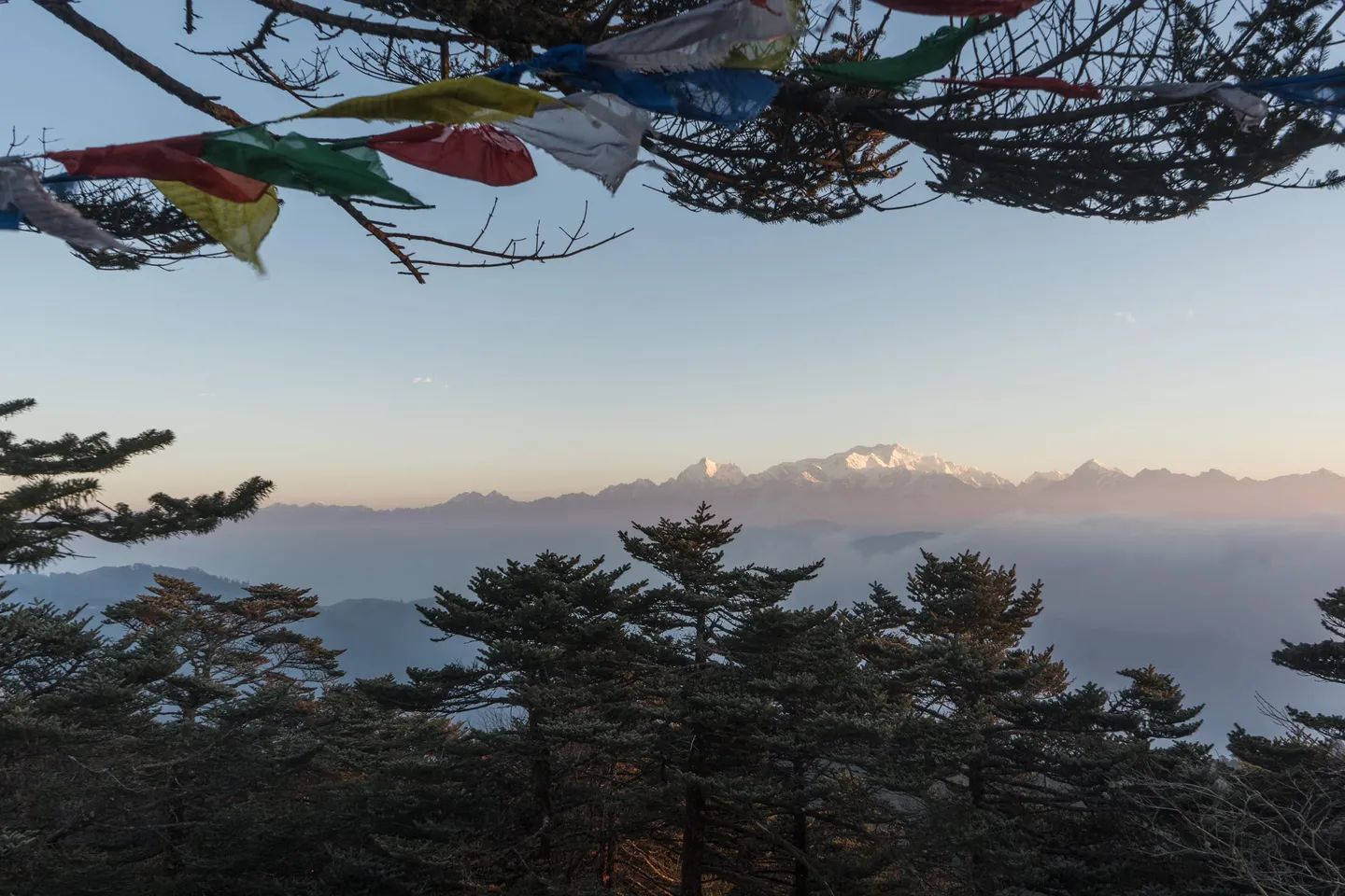
- From Sandakphu at first light: Everest (8,849 m), Kanchenjunga (8,586 m), Lhotse (8,516 m) and Makalu (8,485 m) at once — four of the five highest mountains on earth, from a trek almost anyone reasonably fit can walk.
- The Sleeping Buddha — the Kanchenjunga massif's silhouette read as a reclining figure, with the main summit as the forehead and the ridge falling away left as the face and chest. Once someone points it out you cannot stop seeing it.
- Phalut, where West Bengal, Sikkim and Nepal meet, and where Kanchenjunga is closer and larger than from anywhere else on the walk.
- Red panda country. Singalila National Park is one of the few places in India that holds them, along with clouded leopard, Himalayan black bear and over 120 bird species — a sighting is luck, not itinerary.
- The descent off the ridge into Gorkhey and Srikhola: from bare wind-scoured grass at 3,600 m to a warm river village under 2,000 m in about a day and a half.
Train for consecutive days on your feet rather than for one hard push. Build to 6-8 km of brisk walking four times a week over six to eight weeks, and add hill or stair repeats — the days here are long and rolling rather than steep, and it is the accumulation that tires people. Cold matters more than altitude on this trek: the ridge is exposed for hours at a time and the wind does not stop, so test your layering system on a genuinely cold, windy day before you go rather than discovering its gaps at Sandakphu. If you have never slept above 3,000 m, this is a reasonable place to find out, because the itinerary gains height slowly and there is a road out at almost every point.
- The trail crosses in and out of Nepal repeatedly, often unmarked. Carry government photo ID at all times; foreign nationals should confirm the current requirements with their operator well before travelling.
- A registered guide is mandatory inside Singalila National Park — solo trekking is not permitted — and permits are issued at the forest office at Manebhanjan.
- Published trek distances vary widely, from around 47 km to 75 km, because operators start at Manebhanjan, Dhotrey or Chitrey and end at Srikhola, Sepi or Rimbik. Ask for the day-by-day with distances before you book.
- You sleep in teahouses and lodges, not tents, on the classic route. They are warm and basic; bring a sleeping-bag liner rather than expecting hotel bedding.
- The same track carries walkers and Land Rovers. It is part of the character of the route, and it also means you can be driven out at almost any point if something goes wrong — unusually good for a Himalayan trek.
- The view is the whole point and the view is weather. October to early December is the clearest window; the same trail in July shows you cloud.
Fly to Bagdogra (IXB) or take a train to New Jalpaiguri (NJP), then drive. It is roughly 90-100 km and four to five hours up to Manebhanjan, usually via Darjeeling, which sits 28 km away. Most operators assemble in Darjeeling or NJP and drive up as a group. Darjeeling is the last town with a hospital, a pharmacy and dependable ATMs, and it is close enough to the trailhead to be a genuine fallback rather than a distant one.
- Broken-in trekking shoes or boots with grip — much of the track is rough concrete and loose stone, which is harder on feet than a soft trail
- A genuinely windproof outer shell; on the ridge the wind, not the temperature, is what gets through
- Insulated jacket plus thermal base layers — nights at Sandakphu and Phalut drop below freezing from November
- Sleeping-bag liner for the teahouses (bedding is provided, but layers of it are variable)
- Warm hat, gloves and a buff — the ridge is exposed for hours with nothing to duck behind
- Sunglasses and SPF 50+; the light at 3,600 m is fierce even when the air is cold
- Headlamp for the pre-dawn walk to the Sandakphu viewpoint
- 2 litres of water capacity and purification, plus government photo ID carried on your person
Safety, verified
Safety details last verified 5 Sept 2026 by MadClub.
- Known hazardsVerified
Exposure above all: the Singalila ridge has almost no natural shelter and the wind crosses it unbroken, so wind chill and hypothermia are the real risks rather than altitude. Sub-zero nights at Sandakphu and Phalut from November. Whiteouts that remove both the view and the route in the same hour. A hard track surface that is harder on feet and knees than a soft trail. Unmarked border crossings into Nepal, which is an ID problem rather than a safety one but can become both.
- Permits requiredVerified
Singalila National Park entry permit, issued at the forest office at Manebhanjan and normally arranged by the operator. A registered guide is mandatory inside the park; solo trekking is not permitted. Government photo ID must be carried at all times because the trail crosses the India-Nepal border repeatedly. Foreign nationals face additional requirements — confirm the current position before booking travel.
- Best seasonVerified
October to early December for the clearest views of the Everest and Kanchenjunga ranges, and late March to May for the rhododendron and magnolia bloom (hazier horizons). The monsoon closes the view from June to September. Late December to February is walkable under snow but genuinely cold, with some teahouses shut.
- Maximum altitudeVerified
3,636 m / 11,929 ft at Sandakphu, the highest point in West Bengal (Wikipedia's Singalila National Park article gives 3,630 m — a 6 m difference that changes nothing). Phalut, the second-highest point in the state, is about 3,600 m / 11,800 ft. Sleeping altitudes on the ridge are close to both.
- Getting thereVerified
Bagdogra (IXB) is the nearest airport and New Jalpaiguri (NJP) the nearest railhead; both are roughly 90-100 km and four to five hours from Manebhanjan, usually via Darjeeling. Manebhanjan sits at 1,946 m / 6,325 ft, 28 km from Darjeeling, directly on the India-Nepal border. Darjeeling is the last town with a hospital, pharmacy and dependable ATMs.
- Difficulty noteVerified
Moderate. Height is gained gradually over several days to 3,636 m, nights are spent in teahouses rather than tents, and a vehicle track runs beside almost the whole route. The demand is consecutive days of moderate walking on rough concrete and stone, and hours of exposure to ridge wind. Published distances range from about 47 km to 75 km depending on where an operator starts and finishes.
- Safety equipmentVerified
A genuinely windproof shell, insulated jacket and thermal base layers — the ridge's wind, not its altitude, is what has to be planned for. Broken-in shoes with grip for rough concrete and loose stone, warm hat, gloves and buff, sunglasses and SPF 50+, a headlamp for the pre-dawn viewpoint walk, a sleeping-bag liner for teahouse bedding, and 2 litres of water capacity with purification. Operator kit should include a first-aid set and a pulse oximeter.
- Guide requirementVerified
Mandatory. Singalila National Park rules require a registered guide and do not permit solo trekking. Operators supply a trek leader plus support staff; on this route the guide is also the person who knows which teahouses are open in the shoulder season, which is not a trivial thing at 3,600 m in late November.
- Emergency protocolVerified
Unusually good for a Himalayan trek: the Land Rover track shadows almost the entire route, so an evacuation is a drive rather than a multi-day carry, and Darjeeling — 28 km from the trailhead, with a hospital and pharmacies — is hours away rather than days. Mobile coverage is patchy on the ridge but present in the villages. Confirm before booking that your operator carries a first-aid kit and an oximeter and can name the nearest vehicle point from each night's stop.
- Fitness prerequisiteVerified
One of the more approachable Himalayan treks, and a reasonable first one: gradual height gain, teahouse nights and road access throughout. Expect to walk moderate distances on consecutive days. Train six to eight weeks — build to 6-8 km of brisk walking four times a week, plus hill or stair repeats. No prior high-altitude experience is required, but a tested cold-weather layering system is.
Payment protected — held until your trip starts.
Safety details & FAQ
Can you really see Everest from Sandakphu?
Yes. Sandakphu is one of the very few places on earth from which four of the world's five highest mountains are visible at the same time: Everest (8,849 m), Kanchenjunga (8,586 m), Lhotse (8,516 m) and Makalu (8,485 m). They are about 140 km away, so they read as a distinct white line on the horizon at sunrise rather than as looming walls — the scale takes a moment to register. Clarity is everything, which is why October to early December is the season people plan around.
What is the Sleeping Buddha?
The local name for the profile the Kanchenjunga massif takes when seen from the Singalila ridge: a reclining figure, with the main summit as the forehead and the peaks falling away to the left forming the face, chest and legs. It is a trick of alignment that only works from this angle, which is a large part of why this particular ridge is famous.
Is Sandakphu suitable for a first Himalayan trek?
It is one of the better first ones. The maximum altitude is 3,636 m, height is gained gradually over several days, you sleep in teahouses rather than tents, and a Land Rover track runs alongside almost the entire route, so evacuation is a drive rather than a carry. What it does demand is tolerance for cold and wind on an exposed ridge, and the willingness to walk moderate distances on consecutive days.
How long is the trek, really?
Published figures range from about 47 km to 75 km, and both are honest — operators start at Manebhanjan, Dhotrey or Chitrey and finish at Srikhola, Sepi or Rimbik, and the Phalut extension adds roughly two days. Typical itineraries run 6 to 8 days including travel. Get the day-by-day with distances and overnight stops in writing before you book; on this route it is the single thing that varies most between operators.
When should I go?
October to early December for the clearest mountain views and the sharpest air, and late March to May for the rhododendron and magnolia bloom through the forest below the ridge, at the cost of more haze on the horizon. The monsoon closes the view from June to September. Late December to February is walkable and beautiful under snow, but genuinely cold and some teahouses shut.
What permits do I need?
A Singalila National Park entry permit, issued at the forest office at Manebhanjan and normally arranged by your operator, and a registered guide, which is mandatory inside the park — solo trekking is not allowed. Carry government photo ID throughout, since the trail crosses the India-Nepal border repeatedly. Foreign nationals face additional requirements and should confirm the current position with their operator before booking travel.
Do I have to walk, or can I drive up?
You can drive. The Singalila Land Rover Association runs a fleet of 1950s and 1960s Land Rover Series I up the track to Sandakphu, and that is a legitimate way to see the view if walking several days is not on. It is a different trip, though — the ridge, the forest and the border villages are most of what makes this route worth doing, and they pass in a few hours from a vehicle.
Will I see a red panda?
Probably not, and no operator should promise you will. Singalila National Park is one of the few protected areas in India that holds red panda, along with clouded leopard and Himalayan black bear, and sightings do happen on the forested lower sections. Treat it as luck. The 120-plus bird species are a far more reliable draw.
What's included
- Road transport from New Jalpaiguri (NJP) to Srikhola on Day 1 and back to NJP on Day 7.
- Trek leader, local guides, cook and camp helpers, with horses or porters for the group's load as required.
- Forest Department permits, national park entry and other fees and taxes charged by local authorities.
- Homestay and trekking-hut accommodation for all six nights, from Srikhola on Day 1 to Timburey on Day 6.
- All meals from Srikhola on Day 1 to Srikhola on Day 7 — breakfast, lunch and dinner on every trek day.
- Safety equipment carried by the team: first-aid kit, stretcher, pulse oximeter and a portable oxygen cylinder for emergency use.
What's not included
- Your travel to and from New Jalpaiguri, and any night you spend in NJP before or after the trek.
- Meals, snacks, bottled water, phone calls, tips and other personal expenses on the road transfers between NJP and Srikhola.
- Fees for a doctor or medical officer. The trek leaders are trained in first aid.
- Emergency evacuation costs, whether the cause is medical or the weather.
- Offloading your rucksack onto a horse or porter. You are expected to carry your own pack; offloading is charged separately and depends on the weight.
- Personal trekking gear, insurance, and anything not listed under what is included.
Day-by-day itinerary
NJP to Srikhola. Drive about 129 km, 6 to 7 hours, ending at 2,103 m. Meet at New Jalpaiguri railway station at 6:00 AM and drive up through the Darjeeling hills to Srikhola, the base village for this route. Overnight in a hut at Srikhola.
Reviews
Safety details last verified 5 Sept 2026