 1 / 3
- Photo: Rajeev-Choudhury · CC BY-SA 4.0
- Photo: Sumita Roy Dutta · CC BY-SA 4.0
- Photo: Sumita Roy Dutta · CC BY-SA 4.0
Gulabi Kantha Trek
Hosted by Bharat Outdoors
A five-day trek from Dehradun and back to the crest of Gulabi Kantha at 4,023 m (13,200 ft) in Uttarkashi district, Uttarakhand: a day on the road to Hanuman Chatti, two days up through oak and rhododendron forest to the camps at Kandola Chhani and Seema Thatch, a summit climb that starts in the dark, and the walk and drive home. The plan's day figures add up to 28 km on foot; the mapped trail measures about 20 km. Pages call it easy to moderate; we grade it moderate, because the camps climb fast with no rest day and the winter months bring snow and sub-zero nights, so read the season and altitude notes first.
Trip details
Gulabi Kantha is a five-day trek out of Dehradun and back: a day on the road to Hanuman Chatti, two walking days up through forest and meadow, a summit day that starts in the dark, and a last day that walks down and drives home. From Hanuman Chatti (2,100 m) the trail climbs 5 km to Kandola Chhani (2,700 m) and then 6 km to the high camp at Seema Thatch (3,474 m). Summit day goes up to the crest of Gulabi Kantha at 4,023 m (13,200 ft), about 550 m above that camp, and comes back down to Kandola Chhani the same day. The plan's distances add up to about 28 km on foot; measured along the mapped trail it is 19.7 km, and first-hand accounts count 21 and 26 km. Wikipedia lists Gulabi Kantha among the bugyals of Uttarakhand, the high-altitude meadows. The top is a broad, open, grassy crest, not a sharp peak. On our terrain model it is the highest point of an east-west crest about 2.1 km east-south-east of the Seema Thatch camp in a straight line, and a first-hand January 2026 report crosses several false tops before the real one. That party began the climb at about 4:30 am up a steep stretch where the trail was hard to spot in the dark, reached the top at about 6:30 am in cloud and wind, and was caught by light snow. A mid-April 2022 report describes the last stretch as a steep incline over thick snow that needs proper shoes and preferably a stick. Read the published numbers with care. Pages put the top anywhere from 3,600 m to 4,023 m. The figures of 3,785 to 3,810 m match a mapped ridge trail about 210 m below the crest, not the top; 12,000 ft (3,658 m) is an outlier that no measurement supports; and several pages round the real top to 4,000 m. We use 4,023 m (13,200 ft), the figure on several pages and in a first-hand January 2026 post, and in line with the 4,027 to 4,033 m that three elevation models read at the highest cell of the crest. Walking distances run from 21 km to 28 km on pages and 19.7 km on our map, and summit-day figures from 3 km up on one page to 15 km for the whole day on another; we use the plan's day-by-day figures, which add up to 28 km, and name the spread. Hanuman Chatti is at about 2,100 m by every elevation model we ran; two pages print 2,400 m, which is the height of Nishni, a hamlet about 1 km further up the trail. The season matters more here than on most treks, because the bookable dates run through winter. Pages sell the trek year round, and several say winter is the time to do it, for snow on the meadows; one lists December to April for the snow and September to November for clear views. A mid-April 2022 first-hand report found snow on the top and says it lasts until mid-May or June. February is deep winter: one page says that in December, January and even February the snow can reach 1 to 2 ft, knee deep; one puts night temperatures as low as -10 to -15 °C and another puts winter days at -8 to -2 °C. Snow varies from year to year: the first week of January 2026 had very little, which a first-hand report called rare, and fresh snowfall was reported on 27 January 2026. One operator's own updates describe batches on the trail in February 2026, one going up to the summit and another coming down. We found no first-hand report from February itself. In winter the huts at Kandola Chhani are empty, because the villagers who farm there in summer go down to the valley. The trek starts at Hanuman Chatti, a village in Uttarkashi district, Uttarakhand, at the point where the Hanuman Ganga joins the Yamuna and where the motor road ends below Yamunotri: Wikipedia puts it 14 km from Yamunotri, a first-hand account says 10 km, and our road routing gives 9.4 km. Do not confuse it with a hamlet mapped as Hanumanchatti in Joshimath tehsil, Chamoli district; that is a different place. Whether the route lies in a protected area we could not confirm. Wikipedia says the Bandarpunch massif lies within the Govind Pashu Vihar sanctuary and national park, but the sanctuary's outline on OpenStreetMap is at least 23 km from the points we measured along the route, a forest sign near the trailhead photographed in 2017 names the Yamunotri Range of the Upper Yamuna Forest Division at Barkot, and a forest officer on patrol asked a party for its permits at Kandola Chhani in January 2026. Mind the altitude. On the plan you sleep at 2,100 m, then 2,700 m, then 3,474 m, with no rest day before the summit: night two is 600 m higher than night one and night three is 774 m higher than night two. The NHS advises that, once you are at 3,000 m or more, you avoid sleeping more than 500 m higher than the night before and take a rest day every 3 to 4 days; Wikipedia gives 300 m a day as the rate that prevents altitude sickness. The third night is outside that advice, so tell your guide early about any headache or poor sleep, and stay at Seema Thatch rather than push on if you feel worse.
- Oak and rhododendron forest above Hanuman Chatti (2,100 m, about 6,900 ft), with yew among them by a 2022 report, on the first walking day. The trail passes the hamlet of Nishni on the way; we promise no bloom.
- Kandola Chhani (2,700 m, about 8,900 ft), the first camp, 5 km on foot from the road: seasonal huts and fields that are empty in winter, when the villagers who farm there have gone down to the valley.
- Seema Thatch (3,474 m, about 11,400 ft), the high camp, on a meadow 6 km further up. From the camp the crest to its east hides most of the skyline; on our terrain model only Bandarpunch I and II are clear, so the wide panorama is from the top, not the camp.
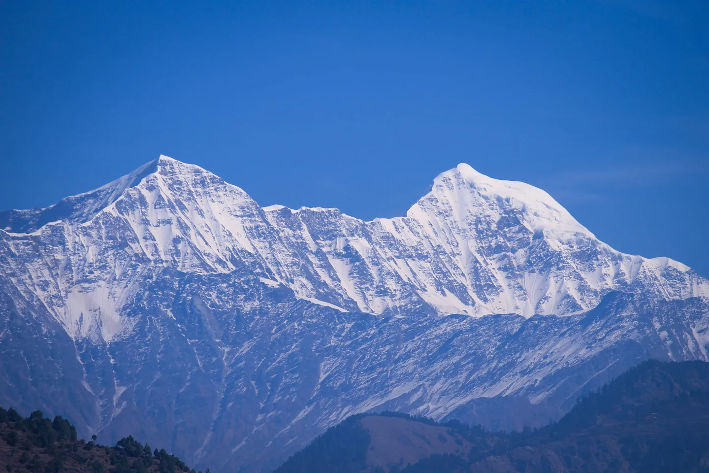
- The crest of Gulabi Kantha (4,023 m, 13,200 ft): a broad, open, grassy top with a long skyline. Several pages name Swargarohini, Bandarpunch, Jaonli and the Gangotri group from it, and our line-of-sight run on a terrain model draws all four as visible; one page also names Srikantha.
- Bandarpunch, the nearest of the big mountains from the top: the White Peak at about 14 km and Bandarpunch I at about 15 km. The massif has three summits: Bandarpunch I (6,316 m), Bandarpunch II or the White Peak (6,102 m), and Kalanag, the Black Peak (6,387 m). They are three different mountains. Several pages name the Black Peak from the top, but on our terrain model it stands directly behind Bandarpunch I and is hidden from the crest, so we promise Bandarpunch I and the White Peak, not the Black Peak.
- Swargarohini and Jaonli (6,632 m) on the horizon, and the Gangotri group beyond. Pages also name Nanda Devi, Chaukhamba and a Kalindi range from the top; those names come from single pages and are not on our terrain model's list of visible mountains, so we do not promise them.
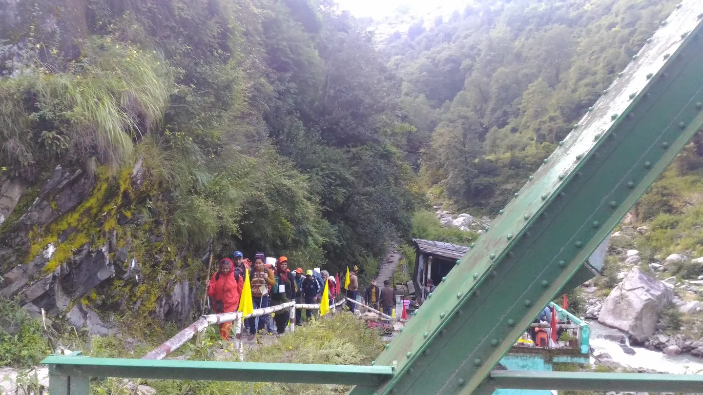
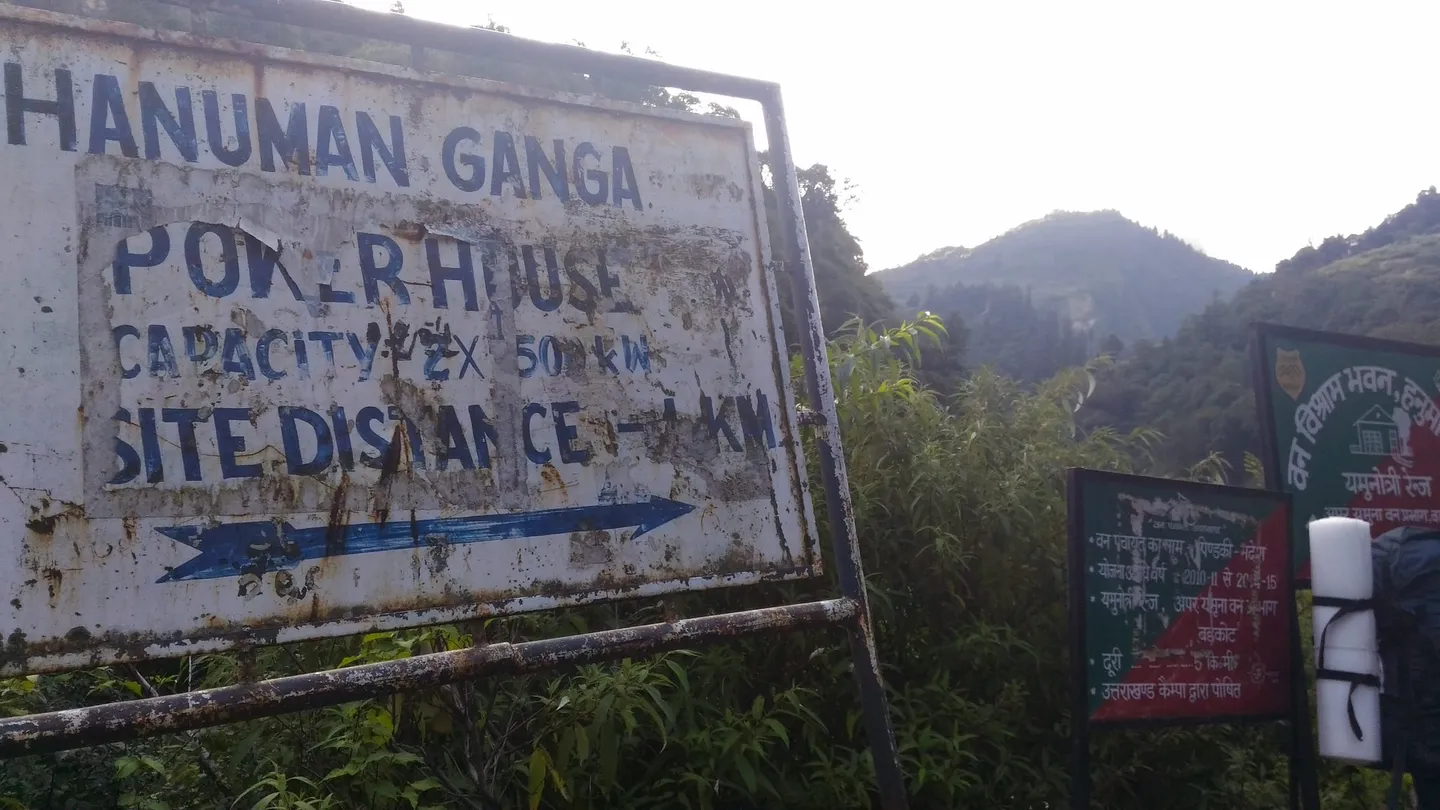
- The Hanuman Ganga beside the lower trail, and the trailhead itself: a railed path, a green steel footbridge and a forest-department board near an old power-house sign. The photographs on this page were taken in September and November, not in the winter snow window, so expect far more snow on the days than they show.
Prepare for the cold and the altitude more than for the distance. The walking days are short on paper, 5 km, 6 km, about 12 km on summit day and 5 km down, and pages call the trek easy to moderate and a beginner's trail with no technical skills. But the top is 4,023 m, you sleep 774 m higher on night three than on night two, summit day starts in the dark, and in winter the trail carries snow and the nights fall well below zero. Train for stairs and hills with a pack, and for several days in a row on your feet. Take the altitude seriously. If you have never slept above 3,000 m, tell your guide, drink and eat regularly, and accept that stopping at Seema Thatch is a sound decision. Altitude sickness usually begins above about 2,500 m, and this plan sleeps at 2,700 m on night two. Get the layers right. A first-hand January 2026 party wore a great many layers to beat the cold on the pre-dawn climb, and a 2022 report says the last stretch needs proper boots and preferably a stick. Practise walking in the boots, gaiters and gloves you will wear before you go. Ask your operator, in writing, four things: which month the departure is and what the snow was doing on the last one, what the summit-day turnaround time is, which permits are included and who obtains them, and what the rescue and evacuation arrangements are. Tell someone who is not on the trek where you are going and when you expect to be back.
- The summit is a decision made on the day. A January 2026 party left in the dark, found the trail hard to spot, reached the top at about 6:30 am in cloud and wind, and was caught by light snow. Whether a party goes up depends on the day's weather and snow; ask your operator what the turnaround rule is.
- The season is wide on paper and narrow in practice. Pages say year round, winter, or September to November for views; first-hand accounts include a mid-April 2022 trip with snow on the top and a January 2026 trip with very little snow. February is deep winter: expect snow, ice and sub-zero nights, in a depth that varies from year to year.
- Published numbers disagree. Top: 3,600 m to 4,023 m on pages (we publish 4,023 m). Total walking: 21 to 28 km on pages and 19.7 km on the mapped trail (we publish the plan's 28 km). Summit day: 3 km up on one page, 11 km for the whole day in a first-hand report, 15 km on another page, and 12 km on the plan.
- The plan sleeps 600 m higher on night two and 774 m higher on night three, with no rest day. That is more than the NHS advises once you are above 3,000 m (no more than 500 m a night), so tell your guide early about any headache or poor sleep.
- Forest permits are part of the arrangements. Pages that sell the trek say permits and camping charges are included for Indian nationals and that foreign nationals pay extra (one 2026 page prints INR 1,600 more). We found no official permit or fee list for this trek, so we publish no fee.
- A January 2026 report says Uttarakhand was drafting trekking rules, with registration for operators and qualifications for guides, that needed government approval. We did not verify whether they are in force. Ask your operator which rules apply.
- We could not confirm whether the route is inside the Govind Pashu Vihar sanctuary and national park. Wikipedia places the Bandarpunch massif inside it; the sanctuary's outline on OpenStreetMap is at least 23 km from the points we measured. Ask your operator.
- A guide is how this trail is done. The trail is hard to spot in the dark on the way to the top, and in winter snow hides it. Do not plan to go without one.
- Medical help is far. The nearest government facility is a health centre at Barkot, about 36 km by road; the district hospital is at Uttarkashi, about 115 km by road. Phone coverage is limited at Barkot and Hanuman Chatti and intermittent to none on the trail.
- The road to Hanuman Chatti is the Yamunotri highway, which landslides have cut in the monsoon (reports from June 2025, August 2025 and July 2026). Road widening was under way in January 2026 and made the Dehradun drive slow and dusty. Leave a margin before any onward train or flight.
- The photographs on this page were taken outside the winter window. Do not expect them to show what you will see.
The plan starts and ends at Dehradun. Operators pick up from the railway station or the ISBT bus stand early in the morning. Day one is a road day from Dehradun to Hanuman Chatti, 180 km in 6 to 7 hours on the plan; routing engines give 156 to 158 km by the shortest road, and pages print 125 to 200 km and 5 to 9 hours, so allow for the longer end. A January 2026 party left Dehradun at about 6:45 am and reached Hanuman Chatti at about 2:30 pm in dust and road-works traffic. Barkot is the last large town, about 36 km before Hanuman Chatti. Buses and shared vehicles run from Dehradun to Barkot and on to Hanuman Chatti; a 2022 report says taxis ply to Hanuman Chatti only at certain times. Hanuman Chatti is a village in Uttarkashi district, mapped at about 30.93 N, 78.40 E. The way home reverses it: day five walks 5 km down from Kandola Chhani to Hanuman Chatti in 3 to 4 hours and drives the 180 km back to Dehradun, ending in the evening. The Yamunotri highway has been cut by landslides in the monsoon, so leave a margin before any onward flight or train.
- Waterproof, ankle-high trekking boots that you have already broken in, and gaiters in winter. A 2022 report says the last stretch needs proper boots. Pack light slippers for camp.
- A trekking pole or stick; the same report advises one for the snow on the final stretch.
- Warm layers you can add and remove: two trek trousers, three quick-dry T-shirts, thermals top and bottom, a fleece, a padded insulated jacket, a waterproof shell, warm waterproof gloves with a spare pair, a woollen cap and a sun cap, and three or four pairs of socks with one of them woollen. A first-hand January 2026 party wore many layers to beat the cold on the pre-dawn climb.
- A headtorch with spare batteries. You start summit day in the dark.
- Sunglasses, sunscreen of SPF 40 or higher and lip balm for snow glare and thin air.
- Water bottles or flasks that hold two litres in all, and snacks for the long summit day.
- A personal first-aid kit, your own medicines and basic toiletries, and a note of anything you are allergic to.
- A 40 to 50 litre rucksack with a rain cover, and a raincoat or poncho.
- Original ID, and copies of your permit paperwork.
- A power bank, and a downloaded offline map.
- A bag for your rubbish. There are no bins above the road.
What's included
- Accommodation in tents or a homestay, as the plan sets out
- All vegetarian meals: breakfast, lunch, tea and dinner
- Professional trek leader and certified local guide
- Technical and safety equipment
- Forest permits and camping fees
- Medical kit with basic first aid, and an oxygen cylinder if required
Safety details & FAQ
Where is the Gulabi Kantha trek, and where does it start?
It is in Uttarkashi district, Uttarakhand. The walk starts at Hanuman Chatti, a village mapped at about 30.93 N, 78.40 E and at 2,100 m, where the Hanuman Ganga joins the Yamuna and the motor road ends below Yamunotri. From there you climb through oak and rhododendron forest to Kandola Chhani and then Seema Thatch, and go for the top on day four. The plan starts and ends at Dehradun. Do not confuse the village with a hamlet mapped as Hanumanchatti in Chamoli district, which is a different place.
What is the highest point on the Gulabi Kantha trek, and why do pages give different heights?
4,023 m (13,200 ft) is the height we use; it is the figure on several pages and in a first-hand January 2026 post, and three elevation models read 4,027 to 4,033 m at the highest cell of the crest. Pages print anything from 3,600 m to 4,023 m: the 3,785 to 3,810 m figures match a mapped ridge trail about 210 m below the crest, several pages round to 4,000 m, and 12,000 ft (3,658 m) is an outlier no measurement supports. From Seema Thatch (3,474 m) the top is about 550 m higher; from Hanuman Chatti (2,100 m) the gain is 1,923 m.
What does the 5-day plan look like?
Dehradun to Dehradun, with the high camp at Seema Thatch. Day 1: drive Dehradun to Hanuman Chatti (2,100 m), 180 km in 6 to 7 hours. Day 2: walk 5 km from Hanuman Chatti to Kandola Chhani (2,700 m) in 4 to 5 hours. Day 3: walk 6 km from Kandola Chhani to Seema Thatch (3,474 m) in 6 to 7 hours. Day 4: summit day, about 6 km up and back from Seema Thatch to the crest (4,023 m) in about 6 hours, then 6 km down to Kandola Chhani in about 4 hours, 12 km and about 10 hours in all. Day 5: walk 5 km from Kandola Chhani down to Hanuman Chatti in 3 to 4 hours, then drive 180 km to Dehradun in 6 to 7 hours, arriving in the evening. The plan's walking adds up to about 28 km; the mapped trail measures 19.7 km, pages print 21 to 28 km and first-hand accounts count 21 and 26 km. Distances and hours are approximate.
How hard is the Gulabi Kantha trek, and what fitness do you need?
Moderate. Pages call it easy to moderate, a beginner's trail with no technical skills, and two first-hand posts agree. We grade it one step above easy because the top is 4,023 m, summit day starts in the dark, the plan sleeps 774 m higher on night three than on night two with no rest day, winter brings snow, ice and sub-zero nights, and help is far away. You need basic fitness and the ability to walk for several days in a row with a pack: the walking days are 5 km, 6 km, about 12 km and 5 km. Pages describe it as suitable for fit beginners.
What is summit day on Gulabi Kantha like?
Early, cold and steep. On the plan it is about 6 km up and back from Seema Thatch in about 6 hours and then 6 km down to Kandola Chhani in about 4 hours. A January 2026 party began the climb at about 4:30 am up a steep stretch where the trail was hard to spot in the dark, crossed several false tops, reached the top at about 6:30 am in cloud and wind, and was caught by light snow. A mid-April 2022 report describes the last stretch as a steep incline over thick snow that needs proper shoes and preferably a stick. The top is a broad grassy crest, not a sharp peak. Distances differ by source: 3 km up on one page, 1 km in a 2022 report, 11 km for the whole day in a first-hand report and 15 km on another page.
When should you go on the Gulabi Kantha trek?
The pages disagree and none is a measured record. They sell it year round and several prefer winter for the snow; one lists December to April for snow and September to November for clear views. A mid-April 2022 first-hand report found snow on the top and says it lasts until mid-May or June. The Yamunotri highway has been cut by landslides in the monsoon months. No month is guaranteed, and the snow varies from year to year.
Can you do the Gulabi Kantha trek in February?
Yes, batches have run in February, and it is deep winter. One operator's updates describe batches on the trail in February 2026, one going up to the summit and another coming down. Expect snow, ice and sub-zero nights: one page says snow in December, January and even February can reach 1 to 2 ft, knee deep; one puts night temperatures as low as -10 to -15 °C and another winter days at -8 to -2 °C. Snow varies from year to year (the first week of January 2026 had very little; fresh snow fell on 27 January 2026). The huts at Kandola Chhani are empty in winter. We found no first-hand report from February itself, and a route change or a turned-back summit is possible.
Do you need a permit, and is the trek inside a protected area?
Forest permits are part of the arrangements, but we found no official permit or fee list for Gulabi Kantha, so we publish no fee. Pages that sell the trek say permits and camping charges are included for Indian nationals and that foreign nationals pay extra (one 2026 page prints INR 1,600 more). A forest officer on patrol asked a party for its permits at Kandola Chhani in January 2026. A January 2026 report says Uttarakhand was drafting trekking rules that needed government approval; we did not verify whether they are in force. Protected area: Wikipedia says the Bandarpunch massif lies within the Govind Pashu Vihar sanctuary and national park, but the sanctuary's outline on OpenStreetMap is at least 23 km from the points we measured along the route, and a forest sign near the trailhead, photographed in 2017, names the Yamunotri Range of the Upper Yamuna Forest Division at Barkot. We could not confirm which applies; ask your operator.
Do you need a guide?
Treat a guide as required. We found no official rule text either way, but the trail is hard to spot in the dark on the way to the top, in winter snow hides it, and a forest officer asked a party for its permits on the trail. A January 2026 report says Uttarakhand was drafting rules on registration of operators and qualifications for guides. Ask your operator for the guide's turnaround time and what the rescue plan is, in writing.
How do you get to Hanuman Chatti, and where do you stay on the way?
The plan starts and ends at Dehradun, where operators pick up from the railway station or the ISBT early in the morning. Day one is a road day of 180 km in 6 to 7 hours on the plan; routing engines give 156 to 158 km, pages print 125 to 200 km and 5 to 9 hours, and a January 2026 party took from about 6:45 am to about 2:30 pm in road-works traffic. Barkot is the last large town, about 36 km before the village. You sleep at Hanuman Chatti on night one. Buses and shared vehicles run Dehradun to Barkot and on to Hanuman Chatti; taxis ply to Hanuman Chatti only at certain times.
Will the altitude be a problem?
It can be. The plan sleeps at 2,100 m, 2,700 m and 3,474 m on its first three nights with no rest day before the summit, so night two is 600 m higher than night one and night three is 774 m higher than night two. The NHS advises not sleeping more than 500 m higher than the night before once you are at 3,000 m or more, and a rest day every 3 to 4 days; Wikipedia gives 300 m a day. Altitude sickness usually begins above about 2,500 m. Tell your guide early about any headache, nausea or poor sleep, and stay at Seema Thatch rather than push on if you feel worse.
Which peaks can you see from the top of Gulabi Kantha?
A long Himalayan skyline. Several pages name Swargarohini, Bandarpunch, Jaonli and the Gangotri group, and our line-of-sight run on a terrain model draws Swargarohini, Bandarpunch I, Srikantha, Gangotri I, Jaonli and Draupadi ka Danda as visible. The Bandarpunch massif is the nearest: the White Peak at about 14 km and Bandarpunch I at about 15 km. The massif has three summits, Bandarpunch I (6,316 m), Bandarpunch II or the White Peak (6,102 m) and Kalanag, the Black Peak (6,387 m); they are three different mountains. Several pages say the Black Peak is visible, but on our terrain model it stands directly behind Bandarpunch I and is hidden, so we do not promise it. Some pages also name Nanda Devi, Chaukhamba and a Kalindi range; we do not, because they are single pages and not on our model's visible list.
Is there phone signal, and where is the nearest hospital?
Coverage is limited at Barkot and Hanuman Chatti and intermittent to none on the trail; do not rely on it. The nearest government health facility is at Barkot, about 36 km by road, which OpenStreetMap maps as a community health centre and the Uttarkashi district site lists as a primary health centre. The district hospital is at Uttarkashi, about 115 km by road. 112 is the single national emergency number; the district site also lists police 100, fire 101, ambulance 108 and disaster management 1077, on a page dated 2019, so confirm them. Reports from 2026 show 112 calls and SDRF teams being used for trekkers in Uttarakhand; neither is about this route.
What should you carry on summit day?
Waterproof ankle-high boots, gaiters in winter, a stick or trekking pole, several warm layers with a waterproof shell and warm waterproof gloves and a hat (a January 2026 party wore many layers on the pre-dawn climb), a headtorch with spare batteries because you start in the dark, sunglasses and sunscreen, a flask and snacks, and a personal first-aid kit. A 2022 report advises proper boots and a stick for the last stretch.
Why do pages disagree on the distance and the height?
Because the figures are rounded and cannot be traced to a survey. The walking is about 28 km if you add up the plan's daily figures and 19.7 km measured along the mapped trail, and pages and first-hand accounts print 21, 24, 25, 26 and 28 km for the trek. Summit day runs from 3 km up on one page to 15 km for the day on another; a first-hand report counts 11 km. The top is printed from 3,600 m to 4,023 m, Seema Thatch at 3,474 m on the plan and 3,400 m on some pages, Kandola Chhani at 2,700 m (one page prints 9,740 ft, about 2,969 m), and Hanuman Chatti at 2,100 m, with two pages printing 2,400 m, which is the height of the hamlet of Nishni about 1 km up the trail. We publish the plan's figures and name the spread.