 1 / 3
1 / 3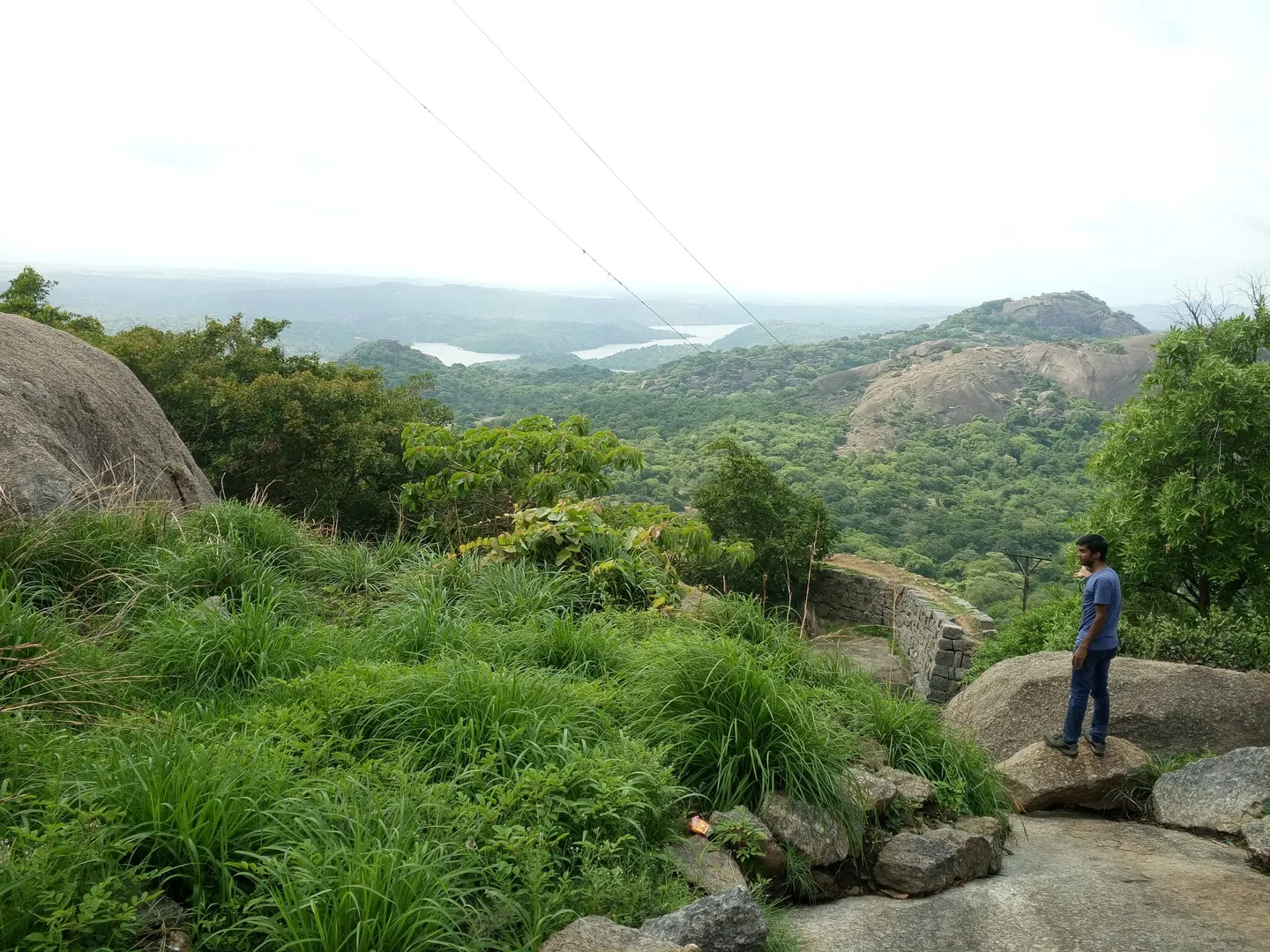
- Photo: Karthik R · CC BY-SA 4.0
- Photo: Karthik R · CC BY-SA 4.0
- Photo: Ashwin06k · CC BY-SA 4.0
Bidarakatte Trek
Hosted by Elegant Adventurers
A short walk on scrub and bare granite inside Savanadurga State Forest, about 60 km west of Bengaluru — 2.5 km from the Kempegowda Tree Park up to a hilltop the Forest Department calls Doddarebylu, past old fort walls and a temple. The name belongs to the lake at the trailhead, not to the village of Bidarakatte — there are at least two of those, in other districts.
Trip details
Start with where this is not. Karnataka has at least two revenue villages called Bidarakatte — one in Tumkur taluk of Tumakuru district, one in Mandya taluk of Mandya district, about 65 km apart in a straight line and 80 km by road — and a third settlement, Bidarakatte Palya, in Kunigal taluk. The walk sold as the Bidarakatte Trek is at none of them. It is a trail inside Savanadurga State Forest in Magadi taluk, about 60 km west of Bengaluru (Bangalore), and the Karnataka Eco-Tourism Development Board's own page for it makes the point itself: navigate to Savanadurga state forest near Ramanagara, and do not confuse it with Bidarakatte off Tumkur. The name belongs to the lake the walk starts at: Indiahikes, which spells the whole trek Bidirukatte, calls Bidiru Katte Lake the largest water body on the route and puts it 500 m in from the gate. Both spellings are worth knowing, because the two fullest listings for this walk use one each. Blogs and booking sites get the district wrong routinely, and several still file the trek under Tumkur. What it actually is, in the Forest Department's own words, is a walk that starts from the Kempegowda Tree Park and follows an incline to the top of the hill at Doddarebylu. The department gives it as 2.50 km and 1.75 hours and grades it moderate. Indiahikes, which has walked the route and published it section by section, gives 5 km both ways — 890 m to the Kempammane Sone pond, 800 m more to the first hilltop through the fort ruins, then 650 m to the temple ruins and 1.2 km back, with an optional 1.3 km detour to a second hill — and calls the whole thing an easy day hike. AllTrails, which has a GPS track and seventeen reviews, records an out-and-back of about 4.8 km with 462 ft — roughly 141 m — of climbing, averaging an hour and twenty minutes, and also calls it easy. Escape2Explore sells it as 5 km; trekentrip says 5-7 km round trip and two to three hours. Those figures agree better than they look: 2.5 km out is 5 km back, and the difference is mostly where a group parks. The ground is scrub and stunted bush over granite, with rock agamas on the slabs, fort walls and the remains of a walled settlement along the way, a temple, and a string of lily ponds. It is also, honestly, thinly documented. Exactly one source gives the hill a height — Indiahikes puts the trek's highest altitude at 3,200 ft, about 975 m — and nothing corroborates it: the Forest Department names the high point Doddarebylu and prints no altitude, and one operator page says only that the hill "stands at a significant elevation". Doddarebylu is not on OpenStreetMap, and neither is the Kempegowda Tree Park. Wikimedia Commons has no photograph of the trail at all. What does get published, and is wrong, is Savanadurga's 1,226 m / 4,022 ft — that is the monolith next door, a different and harder trek from a different start point, and the number travels because the two share a forest and a fee counter, to the point where one operator prints it as this hill's height.
- The Kempegowda Tree Park at the start, a Forest Department plantation beside the Ramanagara division office where the walk begins and where you report.
- Bidiru Katte Lake, the water body the walk is named after, about 500 m in past a children's park. Indiahikes calls it the largest on the route and reports Forest Department benches and a shaded boulder at its edge.
- Doddarebylu, the hilltop the Forest Department names as the end of the trail. No map we could find carries the name, and the only altitude published for the walk's high point is Indiahikes' 3,200 ft.
- Old fort walls and the remains of a walled settlement along the route. The Forest Department names both and identifies neither. Indiahikes describes the summit enclosure as a 16th-century fort built by the Vijayanagara kings, with a long wall along the hill's edge, a single gate on the west called Kailasa Dwara and a watchtower to the south at the highest point; no Forest Department, ASI or scholarly source we found confirms that attribution. Savanadurga next door was a Magadi fortress taken by Lord Cornwallis from Tipu Sultan's forces in 1791, and nothing we found connects these walls to that system.
- An old temple on the trail, unnamed by the Forest Department page that mentions it. Indiahikes calls it a 12th-century Nandi temple built by the Hoysala kings, its deity moved to a nearby village and the carving on its shikhara still intact — again an operator's attribution rather than a departmental or ASI one.
- Ponds with water lilies. The Forest Department mentions one and calls it "a welcome break to the weary trekker"; Indiahikes counts seven along the route and names them. None is a rest stop to get into: Indiahikes says of Basavanna Sone that it is small but deceptively deep and that locals say people have drowned there, and that none of the ponds is safe to drink from.
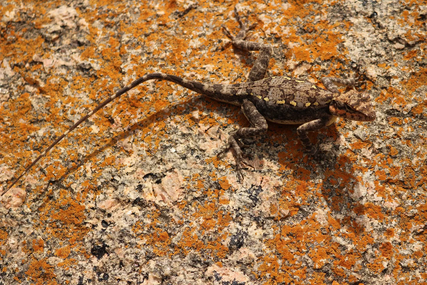
- The peninsular rock agama on the granite slabs — a lizard whose males turn fine vermilion red or yellow in the breeding season, while females and young stay olive-brown and mottled against the rock.
- Yellow-throated bulbul and Sirkeer Malkoha, both named on the Forest Department's page for this trail. The yellow-throated bulbul is a peninsular-Indian endemic of rocky scrub hills; the department's page calls it Endangered, though the IUCN Red List has assessed it as Least Concern since 2016.
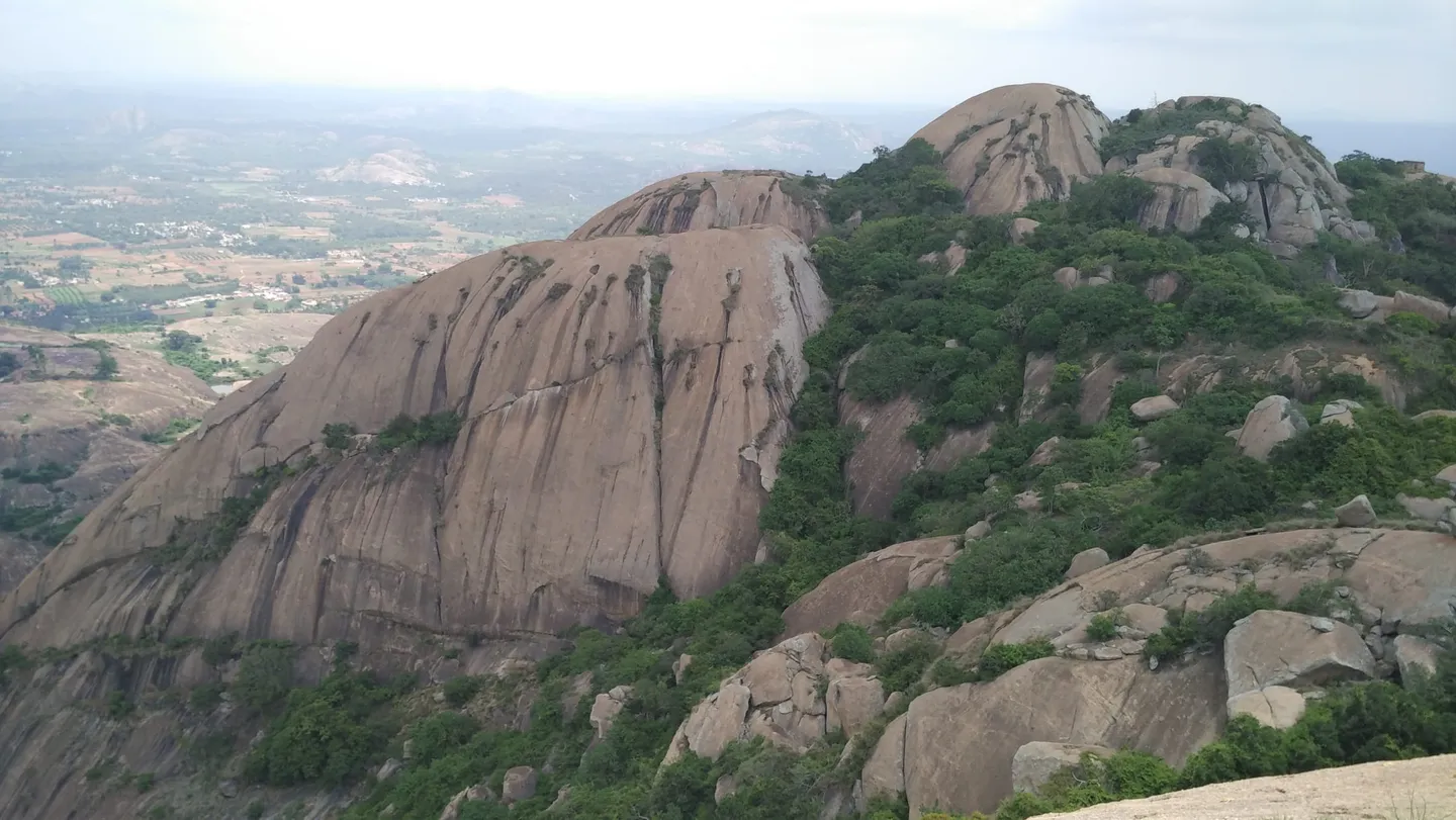
- Savanadurga itself rising beside you — two joined domes called Karigudda, the black hill, and Biligudda, the white hill. Wikipedia gives it 1,226 m / 4,022 ft and Karnataka Tourism 4,024 ft, which is the same hill to within a couple of feet. It is a separate, harder, longer trek from a different trailhead, and its height is not this walk's height.
This is a short walk, so train for the conditions rather than the distance. The hazard here is heat and bare rock, not fitness: the route climbs open granite with almost no shade, the day's single departure goes at first light for exactly that reason, and April is the hottest month around Bengaluru with a mean daily maximum of 34.1°C. The two sources disagree on the hour: the Forest Department's page says 06:30, while Indiahikes says to start at 06:00 sharp and that the guides are only at the gate from six, so an earlier start is not possible. Carry at least two litres of water per person, wear shoes with real grip because dry granite dust on a smooth slab is slippery, and plan for the earlier of the two times rather than the later. If you are used to graded hill paths, be aware that stretches of this walk are rock with no path on them at all, which is the reason people lose the line here.
- This is not any of the villages called Bidarakatte. Two revenue villages of that name exist in Karnataka — Tumkur taluk in Tumakuru district and Mandya taluk in Mandya district — plus Bidarakatte Palya in Kunigal taluk. The Forest Department's own page tells you to set your map to Savanadurga state forest near Ramanagara and warns against confusing it with Bidarakatte off Tumkur. The forest is spelled Savanadurga and the village at its foot is spelled Savandurga; both are the same place, and the district — Ramanagara until 23 May 2025 — is now Bengaluru South. Indiahikes lists this same walk as the Bidirukatte trek, so search both spellings.
- Check that the trail is open before you drive out. The PCCF (Wildlife) and Chief Wildlife Warden issued two circulars on 11 May 2026, after a leopard killed a ten-year-old at MM Hills: the first suspended trekking on forest routes frequented by leopards, tigers, elephants and bears until further orders, and the second suspended trekking anywhere the department's April 2026 safety procedure cannot be fully complied with and certified. On 30 August 2026 the Forest Department issued a trekking SOP that adds locally trained people to accompany trekking groups, daily entry limits and GPS-enabled tracking, and requires a route-wise assessment before any trail reopens; the first reopenings under it went to the Kudremukh Wildlife Division. The first May circular was addressed to the tiger reserves and to the deputy conservators of forests of wildlife divisions, and this walk is a state forest run from the Ramanagara division office rather than a sanctuary, a national park or a tiger reserve — so no published order says either way whether it is affected.
- The Forest Department's booking page for this trek still shows a fee of Rs 250 per person, one start a day at 06:30 and the note "Not for children" — its booking form counts only people above 12. But that page is the superseded portal: it still carries a COVID-era notice, and its booking calendar's list of blocked dates has never moved past January 2022. The department's current portal, Aranya Vihaara, did not list Bengaluru South district at all when we checked on 7 September 2026, while Indiahikes tells trekkers to take the permit from Aranya Vihaara under Ramanagara district treks and to do it at least two days ahead. Ask the Forest Department before you commit to a date — the portal gives 1926 as its helpline and [email protected] as its trekking desk.
- A guide is not optional. Indiahikes states that a local guide is mandatory for this trek and joins the group at the start point, that guides are only there from 06:00 so an earlier start is not possible, and that on-the-spot booking or walking without a permit is not allowed here. The department's own procedure of 17-18 April 2026 puts one nature guide with every ten trekkers, and its SOP of 30 August 2026 adds locally trained people to accompany trekking groups, daily entry limits and GPS-enabled tracking.
- One source publishes an altitude: Indiahikes gives the trek's highest point as 3,200 ft, about 975 m. Nothing corroborates it, so treat it as a single-source figure. If a listing tells you instead that this walk tops out at 1,226 m or 4,022 ft, it has copied Savanadurga's height from next door — one operator does exactly that. What is separately published is the climb: about 462 ft / 141 m of gain on AllTrails' track.
- Savanadurga State Forest holds leopard and sloth bear. Karnataka Tourism's own page for the hill said, in as many words, that because the region is covered by thick vegetation and inhabited by bears and leopards you should not stay at the top after dark, should carry water, food and a first-aid kit, and should always move in groups. That page has since disappeared from the live tourism site and survives only as an Internet Archive snapshot, but the advice is sound and the single dawn start exists partly to enforce it.
- People do get into trouble on this granite. In December 2023 a 30-year-old trekker who lost contact with his companion on the neighbouring Savanadurga hill was found dead after a 100-hour search by police, forest staff, fire services and the SDRF; police said he may have lost his footing and slipped into a ravine, and Magadi police station registered a case. That was the adjacent trail, not this one, but it is the same rock. On this route the drops are real too: Indiahikes tells walkers that the rock surface falls steeply into a valley below the first hilltop and not to go near its edge.
- There is nothing on the hill — no water, no shop, no shade, no toilet. Indiahikes reports a drinking water station at the start point and none beyond it, and tells trekkers to fill two litres there. Magadi town — about 7 miles away by the Forest Department's reckoning, 13 km by Karnataka Tourism's — is the nearest place with a market.
Savanadurga is about 60 km west of Bengaluru (Bangalore), off the Magadi road, and the drive is 1.5 to 2 hours depending on when you leave the city. The Forest Department's own directions send you the longer way round, through Ramanagara, and recommend the NICE Ring Road out of the city to avoid traffic: head for Ramanagara — a leg the district administration, not the department, gives as 50 km on NH275 and about 1.5 hours — turn right at the Ramanagara bus station, run straight for about 40 minutes, then turn right under the arch reading Kempegowda Vanadhama Savanadurga, and the Ramanagara division forest office is five minutes on. Sources differ on the nearest railhead: the district administration names Ramanagara (RMGM) on the South Western Railway's Bengaluru-Mysuru line, 44 km out from Bengaluru, while Karnataka Tourism named Bidadi, 30 km from the hill, on the same line. Both are right in their own terms — Bidadi is closer to Savanadurga, Ramanagara is the district station — and neither is walkable from the trailhead. The nearest airport is Kempegowda International at Devanahalli, which the district administration puts 90 km away and Karnataka Tourism 90 km. No bus goes to the trailhead. Buses between Ramanagara and Magadi pass Savanadurga Cross, and from there it is 3 km to the trek base on foot or by auto — Indiahikes gives Rs 20 a head in a shared auto, or Rs 100 for the whole vehicle. There is parking at the start point, unmonitored.
- Shoes with a grippy sole — the route crosses bare granite, and smooth soles skate on dry rock dust
- Two litres of water per person minimum, filled at the drinking water station at the start point; there is none beyond it, and the ponds are neither drinkable nor safe to swim in
- Sun hat and SPF 50+ — the Forest Department's own description of the vegetation is small trees and stunted bush, which means effectively no shade
- Original government photo ID, since Forest Department trek bookings across Karnataka now require the same ID that was used to book
- A printed or saved copy of your booking, and the Forest Department helpline 1926
- Light full-sleeved clothing rather than shorts, for thorn scrub and sun
- A small first-aid kit with blister cover and an elastic bandage
- Cash for the entry fee in case the counter cannot take a card
- A charged phone, and an agreed turnaround time with someone not on the walk
What's included
- The Karnataka Forest Department entry ticket, Rs 250 per person, paid for the group at the gate.
- The local guide the department requires to accompany every group on this trail.
- A trek leader from Elegant Adventurers.
- Breakfast on the drive back.
- First-aid kit and a pulse oximeter carried by the leader.
Safety details & FAQ
Where exactly is the Bidarakatte trek?
Inside Savanadurga State Forest, in Magadi taluk of Bengaluru South district — the district that was called Ramanagara until 23 May 2025 — about 60 km west of Bengaluru. The Forest Department's page pins it at roughly 12.9138 N, 77.2952 E, which is at the foot of Savanadurga, by the village, the car park and the Veerabhadreshwara temple. It is not the village of Bidarakatte in Tumkur taluk, nor the village of the same name in Mandya taluk, and the Forest Department's page explicitly tells you not to confuse it with "Bidarakatte off Tumkur". Indiahikes lists the same walk under the spelling Bidirukatte, which is also the name of the lake at the trailhead. Several travel blogs file it under Tumkur district anyway.
How high does it go?
About 3,200 ft — roughly 975 m — on Indiahikes' figure, which is the only altitude published for this hill and is corroborated by nobody. The Forest Department names the high point Doddarebylu and gives no altitude at all, and one operator writes only that the hill "stands at a significant elevation". It is at least the right size: SRTM reads about 870 m at the department's own trailhead pin, and AllTrails' GPS track adds 462 ft — about 141 m — of gain, which puts the top a little over 1,000 m. That arithmetic is ours, not a survey, and it is offered as a sanity check on Indiahikes' number rather than as a figure of its own. The 1,226 m / 4,022 ft that turns up on some pages, one operator's included, is Savanadurga, the monolith next door, and it is not this hill.
How long is it, and how long does it take?
The Forest Department gives 2.50 km and 1.75 hours from the Kempegowda Tree Park to Doddarebylu. Indiahikes gives 5 km both ways, broken into sections of 890 m, 800 m, 650 m and 1.2 km with an optional 1.3 km detour to a second hill, and says it is done in under four hours. AllTrails records an out-and-back of about 4.8 km averaging one hour twenty minutes. Escape2Explore lists 5 km; trekentrip sells 5-7 km round trip over two to three hours, which includes time standing about at the top. Plan on a half-morning: you start at first light — 06:30 on the department's page, 06:00 on Indiahikes' — and you will be back at the vehicle well before lunch.
Do I need a permit, and what does it cost?
It is a Forest Department trail, so yes. The Karnataka Eco-Tourism page for Bidarakatte lists Rs 250 per person, one start a day at 06:30 and "Not for children", with booking through the portal. That page is visibly stale — it still carries a COVID-era notice, and its booking calendar's blocked dates stop in January 2022 — and the department's current booking portal, Aranya Vihaara, did not list Bengaluru South district when we checked on 7 September 2026, so this walk was not bookable online there. Indiahikes says the permit comes from Aranya Vihaara under Ramanagara district treks and must be taken at least two days ahead, with no booking on the spot and no walking without one. On top of that, two circulars of 11 May 2026 suspended trekking on wildlife-frequented forest routes until further orders and anywhere the safety procedure is not certified as met, and a trekking SOP issued on 30 August 2026 requires a route-wise assessment before trails reopen. Ask the department first, on 1926 or at [email protected], and confirm before you drive out.
When is the best time to do it?
November to February. IMD's 1991-2020 normals for Bengaluru, the nearest long-record station, give November 64.5 mm of rain, December 15.4 mm, January 1.6 mm and February 7.1 mm, with mean daily minima of about 16-18.5°C — dry, clear and cool. Indiahikes gives September to February, which is the same window with the tail of the monsoon left in. March to May is the wrong end of the year for a shadeless granite walk: April's mean daily maximum is 34.1°C and the record high is 39.2°C. September and October are the two wettest months, at 208.3 mm and 186.4 mm, so early October is often still wet. The Forest Department's page does say the monsoon is a fine time to do this trek for the greenery, which is true, and also when the rock is at its most slippery.
Is it dangerous?
Not by the numbers — it is a five-kilometre round trip with 141 m of climbing. The real risks are heat, bare rock, the water and losing the line. Savanadurga State Forest holds leopard and sloth bear, and Karnataka Tourism's page for the hill told visitors not to stay at the top after dark and always to move in groups. Indiahikes warns that the ponds on this route are deceptively deep, that locals say people have drowned in one of them, and that the rock drops steeply into a valley below the first hilltop. In December 2023 a 30-year-old trekker who lost contact with his companion on the adjacent Savanadurga trail was found dead after a 100-hour search involving police, forest staff, fire services and the SDRF; police said he may have lost his footing and slipped into a ravine. That was a different route on the same rock, and the lesson carries: on open granite there is frequently no path to follow back down.
How does it compare to the Savanadurga trek?
They start from the same forest office and cost the same Rs 250, and the Forest Department describes Bidarakatte as being within close vicinity of the Savanadurga trek. Savanadurga is longer and graded difficult on the department's own page — 4.50 km and 2.50 hours, from Bettada Dari to the Kempegowda fort at the top of a 1,226 m monolith. Bidarakatte is 2.50 km, 1.75 hours and graded moderate, on a lower hill with more scrub and less exposed slab. If you want the big rock and the Nandi mantap at the top, Savanadurga is the one to ask about; if you want fort walls, a temple, birds and far fewer people, this one is — but ask the department first, on 1926 or at [email protected], because neither walk was bookable on Aranya Vihaara when we checked on 7 September 2026.